A | B | C | D | E | F | G | H | CH | I | J | K | L | M | N | O | P | Q | R | S | T | U | V | W | X | Y | Z | 0 | 1 | 2 | 3 | 4 | 5 | 6 | 7 | 8 | 9
Canary Islands
Canarias (Spanish) | |
|---|---|
| Anthem: Himno de Canarias "Anthem of the Canaries" | |
_in_Spain.svg) Location of the Canary Islands relative to the Spanish mainland | |
| Coordinates: 28°N 16°W / 28°N 16°WCoordinates: 28°N 16°W / 28°N 16°W | |
| Country | |
| Largest city | Las Palmas de Gran Canaria |
| Capital | Las Palmas de Gran Canaria and Santa Cruz de Tenerife[1] |
| Provinces | Las Palmas, and Santa Cruz de Tenerife |
| Government | |
| • President | Ángel Víctor Torres (PSC–PSOE) |
| Area | |
| • Total | 7,493 km2 (2,893 sq mi) |
| • Rank | 1.88% of Spain; ranked 13th |
| Population (2019)[2] | |
| • Total | 2,153,389 |
| • Rank | 8th |
| • Density | 290/km2 (740/sq mi) |
| • Percentage | 4.58% of Spain |
| Demonyms | Canarian canario/-a (Spanish) |
| Time zone | UTC (WET) |
| • Summer (DST) | UTC+1 (WEST) |
| ISO 3166 code |
|
| Most populated island | Tenerife[2] |
| Official language | Spanish |
| Statute of Autonomy | 7 November 2018 |
| Parliament | Canarian Parliament |
| Congress seats | 15 (of 350) |
| Senate seats | 14 (of 265) |
| HDI (2018) | 0.861[3] very high · 15th |
| Website | www |
.svg)

The Canary Islands (/kəˈnɛəri/; Spanish: Canarias, pronounced ), also known informally as the Canaries, are a Spanish region and archipelago in the Atlantic Ocean, in Macaronesia. At their closest point to the African mainland, they are 100 kilometres (62 miles) west of Morocco. They are the southernmost of the autonomous communities of Spain. The islands have a population of 2.2 million people and they are one of the outermost regions of the European Union.[4][5]
The eight main islands are (from largest to smallest in area) Tenerife, Fuerteventura, Gran Canaria, Lanzarote, La Palma, La Gomera, El Hierro and La Graciosa. The archipelago includes many smaller islands and islets, including Alegranza, Isla de Lobos, Montaña Clara, Roque del Oeste, and Roque del Este. It also includes a number of rocks, including those of Salmor, Fasnia, Bonanza, Garachico, and Anaga. In ancient times, the island chain was often referred to as "the Fortunate Isles".[6] The Canary Islands are the southernmost region of Spain, and the largest and most populous archipelago of Macaronesia.[7] Because of their location, the Canary Islands have historically been considered a link between the four continents of Africa, North America, South America, and Europe.[8]
In 2019, the Canary Islands had a population of 2,153,389,[2] with a density of 287.39 inhabitants per km2, making it the eighth most populous autonomous community of Spain. The population is mostly concentrated in the two capital islands: around 43% on the island of Tenerife and 40% on the island of Gran Canaria.
The Canary Islands, especially Tenerife, Gran Canaria, Fuerteventura, and Lanzarote, are a major tourist destination, with over 12 million visitors per year. This is due to their beaches, subtropical climate, and important natural attractions, especially Maspalomas in Gran Canaria, Teide National Park, and Mount Teide (a World Heritage Site) in Tenerife. Mount Teide is the highest peak in Spain and the third tallest volcano in the world, measured from its base on the ocean floor.[9][10] The islands have warm summers and winters warm enough for the climate to be technically tropical at sea level.[11] The amount of precipitation and the level of maritime moderation vary depending on location and elevation. The archipelago includes green areas as well as desert areas. The islands’ high mountains are ideal for astronomical observation, because they lie above the temperature inversion layer. As a result, the archipelago boasts two professional observatories: Teide Observatory on the island of Tenerife, and Roque de los Muchachos Observatory on the island of La Palma.[12]
In 1927, the Province of Canary Islands was split into two provinces. In 1982, the autonomous community of the Canary Islands was established. The cities of Santa Cruz de Tenerife and Las Palmas de Gran Canaria are, jointly, the capital of the islands.[13][14] Those cities are also, respectively, the capitals of the provinces of Santa Cruz de Tenerife and Las Palmas. Las Palmas de Gran Canaria has been the largest city in the Canaries since 1768, except for a brief period in the 1910s.[15] Between the 1833 territorial division of Spain and 1927, Santa Cruz de Tenerife was the sole capital of the Canary Islands. In 1927, it was ordered by decree that the capital of the Canary Islands would be shared between two cities, and this arrangement persists to the present day.[16][17] The third largest city in the Canary Islands is San Cristóbal de La Laguna (a World Heritage Site) on Tenerife.[18][19][20] This city is also home to the Consejo Consultivo de Canarias, which is the supreme consultative body of the Canary Islands.[21]
During the Age of Sail, the islands were the main stopover for Spanish galleons on their way to the Americas, which sailed that far south in order to catch the prevailing northeasterly trade winds.[22][23]
Etymology
The name Islas Canarias is likely derived from the Latin name Canariae Insulae, meaning "Islands of the Dogs", a name that was evidently generalized from the ancient name of one of these islands, Canaria – presumably Gran Canaria. According to the historian Pliny the Elder, the island Canaria contained "vast multitudes of dogs of very large size".[24]
Other theories speculate that the name comes from the Nukkari Berber tribe living in the Moroccan Atlas, named in Roman sources as Canarii, though Pliny again mentions the relation of this term with dogs.[25] The connection to dogs is retained in their depiction on the islands' coat-of-arms. It is thought that the aborigines of Gran Canaria called themselves "Canarios".[26] It is possible that after being conquered, this name was used in plural in Spanish, i.e., as to refer to all of the islands as the Canarii-as.[26]
The name of the islands is not derived from the canary bird; rather, the birds are named after the islands.
Physical geography


Tenerife is the largest and most populous island of the archipelago. Gran Canaria, with 865,070 inhabitants, is both the Canary Islands' second most populous island, and the third most populous one in Spain after Tenerife (966,354 inhabitants) and Majorca (896,038 inhabitants).[27] The island of Fuerteventura is the second largest in the archipelago and located 100 km (62 mi) from the African coast.
The islands form the Macaronesia ecoregion with the Azores, Cape Verde, Madeira, and the Savage Isles.[28] The Canary Islands is the largest and most populated archipelago of the Macaronesia region.[7] The archipelago consists of seven large and several smaller islands, all of which are volcanic in origin.[29] The antipodes of the Canary Islands are found in the Pacific Ocean, between New Zealand, New Caledonia, Australia and the ocean.[30]
According to the position of the islands with respect to the north-east trade winds, the climate can be mild and wet or very dry. Several native species form laurisilva forests.
As a consequence, the individual islands in the Canary archipelago tend to have distinct microclimates. Those islands such as El Hierro, La Palma and La Gomera lying to the west of the archipelago have a climate which is influenced by the moist Canary Current. They are well vegetated even at low levels and have extensive tracts of sub-tropical laurisilva forest. As one travels east toward the African coast, the influence of the current diminishes, and the islands become increasingly arid. Fuerteventura and Lanzarote, the islands which are closest to the African mainland, are effectively desert or semi desert. Gran Canaria is known as a "continent in miniature" for its diverse landscapes like Maspalomas and Roque Nublo. In terms of its climate Tenerife is particularly interesting. The north of the island lies under the influence of the moist Atlantic winds and is well vegetated, while the south of the island around the tourist resorts of Playa de las Américas and Los Cristianos is arid. The island rises to almost 4,000 m (13,000 ft) above sea level, and at altitude, in the cool relatively wet climate, forests of the endemic pine Pinus canariensis thrive. Many of the plant species in the Canary Islands, like the Canary Island pine and the dragon tree, Dracaena draco are endemic, as noted by Sabin Berthelot and Philip Barker Webb in their work, L'Histoire Naturelle des Îles Canaries (1835–50).[31]
Climate
The climate is warm subtropical and generally semidesertic, moderated by the sea and in summer by the trade winds.[32] There are a number of microclimates and the classifications range mainly from semi-arid to desert. According to Köppen,[33] the majority of the Canary Islands have a hot desert climate represented as BWh, caused partly due to the cool Canary Current. There also exists a subtropical humid climate which is very influenced by the ocean in the middle of the islands of La Gomera, Tenerife and La Palma, where laurisilva cloud forests grow.[34]
| Climate data for Santa Cruz de Tenerife 35m (1981–2010) | |||||||||||||
|---|---|---|---|---|---|---|---|---|---|---|---|---|---|
| Month | Jan | Feb | Mar | Apr | May | Jun | Jul | Aug | Sep | Oct | Nov | Dec | Year |
| Average high °C (°F) | 21.0 (69.8) |
21.2 (70.2) |
22.1 (71.8) |
22.7 (72.9) |
24.1 (75.4) |
26.2 (79.2) |
28.7 (83.7) |
29.0 (84.2) |
28.1 (82.6) |
26.3 (79.3) |
24.1 (75.4) |
22.1 (71.8) |
24.6 (76.3) |
| Daily mean °C (°F) | 18.2 (64.8) |
18.3 (64.9) |
19.0 (66.2) |
19.7 (67.5) |
21.0 (69.8) |
22.9 (73.2) |
25.0 (77.0) |
25.5 (77.9) |
24.9 (76.8) |
23.4 (74.1) |
21.3 (70.3) |
19.4 (66.9) |
21.5 (70.7) |
| Average low °C (°F) | 15.4 (59.7) |
15.3 (59.5) |
15.9 (60.6) |
16.5 (61.7) |
17.8 (64.0) |
19.5 (67.1) |
21.2 (70.2) |
21.9 (71.4) |
21.7 (71.1) |
20.3 (68.5) |
18.4 (65.1) |
16.6 (61.9) |
18.4 (65.1) |
| Average rainfall mm (inches) | 31.5 (1.24) |
35.4 (1.39) |
37.8 (1.49) |
11.6 (0.46) |
3.6 (0.14) |
0.9 (0.04) |
0.1 (0.00) |
2.0 (0.08) |
6.8 (0.27) |
18.7 (0.74) |
34.1 (1.34) |
43.2 (1.70) |
225.7 (8.89) |
| Average rainy days (≥ 1.0 mm) | 8.0 | 7.2 | 6.9 | 5.5 | 2.9 | 0.9 | 0.2 | 0.8 | 2.7 | 6.1 | 8.8 | 9.4 | 59.4 |
| Mean monthly sunshine hours | 178 | 186 | 221 | 237 | 282 | 306 | 337 | 319 | 253 | 222 | 178 | 168 | 2,887 |
| Source: Agencia Estatal de Meteorología[35] | |||||||||||||
| Climate data for Gran Canaria Airport 24m (1981–2010) | |||||||||||||
|---|---|---|---|---|---|---|---|---|---|---|---|---|---|
| Month | Jan | Feb | Mar | Apr | May | Jun | Jul | Aug | Sep | Oct | Nov | Dec | Year |
| Average high °C (°F) | 20.8 (69.4) |
21.2 (70.2) |
22.3 (72.1) |
22.6 (72.7) |
23.6 (74.5) |
25.3 (77.5) |
26.9 (80.4) |
27.5 (81.5) |
27.2 (81.0) |
26.2 (79.2) |
24.2 (75.6) |
22.2 (72.0) |
24.2 (75.6) |
| Daily mean °C (°F) | 18.1 (64.6) |
18.4 (65.1) |
19.3 (66.7) |
19.5 (67.1) |
20.5 (68.9) |
22.2 (72.0) |
23.8 (74.8) |
24.6 (76.3) |
24.3 (75.7) |
23.1 (73.6) |
21.2 (70.2) |
19.3 (66.7) |
21.2 (70.2) |
| Average low °C (°F) | 15.3 (59.5) |
15.6 (60.1) |
16.2 (61.2) |
16.3 (61.3) |
17.3 (63.1) |
19.2 (66.6) |
20.8 (69.4) |
21.6 (70.9) |
21.4 (70.5) |
20.1 (68.2) |
18.1 (64.6) |
16.5 (61.7) |
18.2 (64.8) |
| Average precipitation mm (inches) | 25 (1.0) |
24 (0.9) |
13 (0.5) |
6 (0.2) |
1 (0.0) |
0 (0) |
0 (0) |
0 (0) |
9 (0.4) |
16 (0.6) |
22 (0.9) |
31 (1.2) |
151 (5.9) |
| Average precipitation days (≥ 1 mm) | 3 | 3 | 2 | 1 | 0 | 0 | 0 | 0 | 1 | 2 | 4 | 5 | 22 |
| Mean monthly sunshine hours | 184 | 191 | 229 | 228 | 272 | 284 | 308 | 300 | 241 | 220 | 185 | 179 | 2,821 |
| Source: World Meteorological Organization (UN),[36] Agencia Estatal de Meteorología[37] | |||||||||||||
| Climate data for San Cristóbal de La Laguna (1981–2010) 632 m – Tenerife North Airport | |||||||||||||
|---|---|---|---|---|---|---|---|---|---|---|---|---|---|
| Month | Jan | Feb | Mar | Apr | May | Jun | Jul | Aug | Sep | Oct | Nov | Dec | Year |
| Average high °C (°F) | 16.0 (60.8) |
16.7 (62.1) |
18.2 (64.8) |
18.5 (65.3) |
20.1 (68.2) |
22.2 (72.0) |
24.7 (76.5) |
25.7 (78.3) |
24.9 (76.8) |
22.5 (72.5) |
19.7 (67.5) |
17.1 (62.8) |
20.5 (68.9) |
| Daily mean °C (°F) | 13.1 (55.6) |
13.4 (56.1) |
14.5 (58.1) |
14.7 (58.5) |
16.1 (61.0) |
18.1 (64.6) |
20.2 (68.4) |
21.2 (70.2) |
20.7 (69.3) |
18.9 (66.0) |
16.5 (61.7) |
14.3 (57.7) |
16.8 (62.2) |
| Average low °C (°F) | 10.2 (50.4) |
10.0 (50.0) |
10.7 (51.3) |
10.9 (51.6) |
12.0 (53.6) |
14.0 (57.2) |
15.7 (60.3) |
16.6 (61.9) |
16.5 (61.7) |
15.2 (59.4) |
13.3 (55.9) |
11.5 (52.7) |
13.0 (55.4) |
| Average rainfall mm (inches) | 80 (3.1) |
70 (2.8) |
61 (2.4) |
39 (1.5) |
19 (0.7) |
11 (0.4) |
6 (0.2) |
5 (0.2) |
16 (0.6) |
47 (1.9) |
81 (3.2) |
82 (3.2) |
517 (20.2) |
| Average rainy days (≥ 1.0 mm) | 11 | 10 | 10 | 10 | 7 | 4 | 3 | 3 | 5 | 10 | 10 | 12 | 95 |
| Mean monthly sunshine hours | 150 | 168 | 188 | 203 | 234 | 237 | 262 | 269 | 213 | 194 | 155 | 137 | 2,410 |
| Source: Agencia Estatal de Meteorología[38] | |||||||||||||
| Climate data for Tenerife South Airport 64m (1981–2010) | |||||||||||||
|---|---|---|---|---|---|---|---|---|---|---|---|---|---|
| Month | Jan | Feb | Mar | Apr | May | Jun | Jul | Aug | Sep | Oct | Nov | Dec | Year |
| Average high °C (°F) | 21.7 (71.1) |
22.0 (71.6) |
23.1 (73.6) |
23.1 (73.6) |
23.9 (75.0) |
25.4 (77.7) |
27.7 (81.9) |
28.4 (83.1) |
27.9 (82.2) |
26.8 (80.2) |
24.8 (76.6) |
22.8 (73.0) |
24.8 (76.6) |
| Daily mean °C (°F) | 18.4 (65.1) |
18.5 (65.3) |
19.3 (66.7) |
19.5 (67.1) |
20.4 (68.7) |
22.1 (71.8) |
24.0 (75.2) |
24.7 (76.5) |
24.5 (76.1) |
23.4 (74.1) |
21.5 (70.7) |
19.7 (67.5) |
21.4 (70.5) |
| Average low °C (°F) | 15.2 (59.4) |
15.0 (59.0) |
15.6 (60.1) |
16.0 (60.8) |
17.0 (62.6) |
18.8 (65.8) |
20.2 (68.4) |
21.1 (70.0) |
21.1 (70.0) |
20.0 (68.0) |
18.2 (64.8) |
16.5 (61.7) |
17.9 (64.2) |
| Average rainfall mm (inches) | 16.6 (0.65) |
19.9 (0.78) |
14.7 (0.58) |
7.4 (0.29) |
1.1 (0.04) |
0.1 (0.00) |
0.1 (0.00) |
1.3 (0.05) |
3.6 (0.14) |
11.9 (0.47) |
26.3 (1.04) |
30.3 (1.19) |
133.3 (5.23) |
| Average rainy days (≥ 1.0 mm) | 1.8 | 2.2 | 1.9 | 1.1 | 0.3 | 0.0 | 0.0 | 0.2 | 0.6 | 1.6 | 1.9 | 3.5 | 15.1 |
| Mean monthly sunshine hours | 193 | 195 | 226 | 219 | 246 | 259 | 295 | 277 | 213 | 214 | 193 | 195 | 2,725 |
| Source: Agencia Estatal de Meteorología[37] | |||||||||||||
| Climate data for La Palma Airport 33m (1981–2010) | |||||||||||||
|---|---|---|---|---|---|---|---|---|---|---|---|---|---|
| Month | Jan | Feb | Mar | Apr | May | Jun | Jul | Aug | Sep | Oct | Nov | Dec | Year |
| Average high °C (°F) | 20.6 (69.1) |
20.7 (69.3) |
21.2 (70.2) |
21.6 (70.9) |
22.6 (72.7) |
24.1 (75.4) |
25.5 (77.9) |
26.3 (79.3) |
26.6 (79.9) |
25.5 (77.9) |
23.5 (74.3) |
21.8 (71.2) |
23.3 (74.0) |
| Daily mean °C (°F) | 18.1 (64.6) |
18.0 (64.4) |
18.5 (65.3) |
18.9 (66.0) |
20.0 (68.0) |
21.7 (71.1) |
23.1 (73.6) |
23.9 (75.0) |
24.0 (75.2) |
22.8 (73.0) |
20.9 (69.6) |
19.3 (66.7) |
20.8 (69.4) |
| Average low °C (°F) | 15.5 (59.9) |
15.3 (59.5) |
15.7 (60.3) |
16.2 (61.2) |
17.4 (63.3) |
19.2 (66.6) |
20.7 (69.3) |
21.4 (70.5) |
21.3 (70.3) |
20.2 (68.4) |
18.3 (64.9) |
16.7 (62.1) |
18.2 (64.7) |
| Average rainfall mm (inches) | 49 (1.9) |
57 (2.2) |
33 (1.3) |
19 (0.7) |
7 (0.3) |
2 (0.1) |
1 (0.0) |
1 (0.0) |
12 (0.5) |
41 (1.6) |
70 (2.8) |
80 (3.1) |
372 (14.5) |
| Average rainy days | 5 | 4 | 4 | 3 | 1 | 0 | 0 | 0 | 2 | 5 | 7 | 8 | 40 |
| Mean monthly sunshine hours | 141 | 146 | 177 | 174 | 192 | 188 | 222 | 209 | 187 | 175 | 140 | 138 | 2,106 |
| Source: Agencia Estatal de Meteorología[39] | |||||||||||||
Geology

The seven major islands, one minor island, and several small islets were originally volcanic islands, formed by the Canary hotspot.[40] The Canary Islands is the only place in Spain where volcanic eruptions have been recorded during the Modern Era, with some volcanoes still active (El Hierro, 2011).[41] Volcanic islands such as those in the Canary chain often have steep ocean cliffs caused by catastrophic debris avalanches and landslides.[42] The island chain's most recent eruption occurred at Cumbre Vieja, a volcanic ridge on La Palma, in 2021.[43]
The Teide volcano on Tenerife is the highest mountain in Spain, and the third tallest volcano on Earth on a volcanic ocean island.[44] All the islands except La Gomera have been active in the last million years; four of them (Lanzarote, Tenerife, La Palma and El Hierro) have historical records of eruptions since European discovery.[45] The islands rise from Jurassic oceanic crust associated with the opening of the Atlantic. Underwater magmatism commenced during the Cretaceous, and continued to the present day. The current islands reached the ocean's surface during the Miocene. The islands were once considered as a distinct physiographic section of the Atlas Mountains province, which in turn is part of the larger African Alpine System division, but are nowadays recognized as being related to a magmatic hot spot.[46]
In the summer of 2011 a series of low-magnitude earthquakes occurred beneath El Hierro. These had a linear trend of northeast–southwest. In October a submarine eruption occurred about 2 km (1+1⁄4 mi) south of Restinga. This eruption produced gases and pumice, but no explosive activity was reported.[47]
The following table shows the highest mountains in each of the islands:

| Mountain | Elevation | Island | |
|---|---|---|---|
| m | ft | ||
| Teide | 3,715 | 12,188 | Tenerife |
| Roque de los Muchachos | 2,426 | 7,959 | La Palma |
| Pico de las Nieves | 1,949 | 6,394 | Gran Canaria |
| Pico de Malpaso | 1,501 | 4,925 | El Hierro |
| Garajonay | 1,487 | 4,879 | La Gomera |
| Pico de la Zarza | 812 | 2,664 | Fuerteventura |
| Peñas del Chache | 670 | 2,200 | Lanzarote |
| Aguja Grande | 266 | 873 | La Graciosa |
| Caldera de Alegranza | 289 | 948 | Alegranza |
| Caldera de Lobos | 126 | 413 | Lobos |
| La Mariana | 256 | 840 | Montaña Clara |
Natural symbols
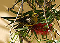
The official natural symbols associated with Canary Islands are the bird Serinus canaria (canary) and the Phoenix canariensis palm.[52]
- Zdroj:https://en.wikipedia.org?pojem=Canary_Islands
>Text je dostupný pod licencí Creative Commons Uveďte autora – Zachovejte licenci, případně za dalších podmínek. Podrobnosti naleznete na stránce Podmínky užití.

Text je dostupný za podmienok Creative
Commons Attribution/Share-Alike License 3.0 Unported; prípadne za ďalších
podmienok.
Podrobnejšie informácie nájdete na stránke Podmienky
použitia.

