A | B | C | D | E | F | G | H | CH | I | J | K | L | M | N | O | P | Q | R | S | T | U | V | W | X | Y | Z | 0 | 1 | 2 | 3 | 4 | 5 | 6 | 7 | 8 | 9


In geography, a cape is a headland or a promontory of large size extending into a body of water, usually the sea.[1] A cape usually represents a marked change in trend of the coastline which makes them prone to natural forms of erosion, mainly tidal actions. This results in capes having a relatively short geological lifespan. Capes can be formed by glaciers, volcanoes, and changes in sea level. Erosion plays a large role in each of these methods of formation.[citation needed]
List of some well-known capes
Gallery
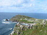
Cape Cornwall, England
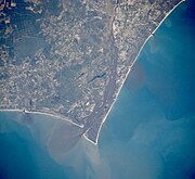
Satellite image of Cape Fear, North Carolina

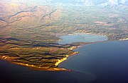
Cape MacLear, Malawi
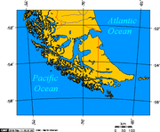
Map depicting Cape Horn at the southernmost portion of South America

Photograph of Cabo Mayor in Santander, Spain
Photograph of Cape Cambell, New Zealand, at sunrise


.jpg)


See also
- Extreme points of Africa
- Extreme points of Asia
- Extreme points of Europe
- Extreme points of North America
- Extreme points of South America
References
- ^ Whittow, John (1984). Dictionary of Physical Geography. London: Penguin, 1984, p. 80. ISBN 0-14-051094-X.
External links


>Text je dostupný pod licencí Creative Commons Uveďte autora – Zachovejte licenci, případně za dalších podmínek. Podrobnosti naleznete na stránce Podmínky užití.
Text je dostupný za podmienok Creative
Commons Attribution/Share-Alike License 3.0 Unported; prípadne za ďalších
podmienok.
Podrobnejšie informácie nájdete na stránke Podmienky
použitia.

