A | B | C | D | E | F | G | H | CH | I | J | K | L | M | N | O | P | Q | R | S | T | U | V | W | X | Y | Z | 0 | 1 | 2 | 3 | 4 | 5 | 6 | 7 | 8 | 9
Tangier
طنجة | |
|---|---|
 .jpg) _(cropped).jpg) .jpg) Clockwise from top: View towards the Medina, courtyard of Kasbah Palace, waterfront from Achakar, Cape Spartel lighthouse | |
 Seal | |
| Nickname(s): The blue and white city, City of the Boughaz, Bride of the North | |
 Tangier Location of Tangier within Morocco  Tangier Tangier (Africa) | |
| Coordinates: 35°46′36″N 05°48′14″W / 35.77667°N 5.80389°W | |
| Country | |
| Region | Tanger-Tetouan-Al Hoceima |
| Government | |
| • Mayor | Mounir Laymouri |
| Area | |
| • Total | 124 km2 (48 sq mi) |
| Highest elevation | 230 m (750 ft) |
| Lowest elevation | 0 m (0 ft) |
| Population (2014)[2] | |
| • Total | 947,952 |
| • Rank | 3rd in Morocco[3] |
| • Density | 7,026/km2 (18,200/sq mi) |
| [a] | |
| Demonym(s) | Tanjawi, Tangierian |
| Time zone | UTC+1 (CET) |
| Postal codes |
|
| Area code | 0539 |
| Website | tanger |
| |
Tangier (/tænˈdʒɪər/ tan-JEER; Arabic: طنجة, romanized: Ṭanjah, [tˤandʒa], [tˤanʒa]) or Tangiers is a city in northwestern Morocco, on the coasts of the Mediterranean Sea and the Atlantic Ocean. The city is the capital of the Tanger-Tetouan-Al Hoceima region, as well as the Tangier-Assilah Prefecture of Morocco.
Many civilisations and cultures have influenced the history of Tangier, starting from before the 10th century BCE. Starting as a strategic Phoenician town and trading centre, Tangier has been a nexus for many cultures. In 1923, it became an international zone managed by colonial powers and became a destination for many European and American diplomats, spies, bohemians, writers and businessmen. That status came to an end with Moroccan independence, in phases between 1956 and 1960.
By the early 21st century, Tangier was undergoing rapid development and modernisation. Projects include tourism projects along the bay, a modern business district called Tangier City Centre, an airport terminal, and a football stadium. Tangier's economy is set to benefit greatly from the Tanger-Med port.
Names
The Carthaginian name of the city is variously recorded as TNG (Punic: 𐤕𐤍𐤂), TNGʾ (𐤕𐤍𐤂𐤀), TYNGʾ (𐤕𐤉𐤍𐤂𐤀),[4] and TTGʾ (𐤕𐤕𐤂𐤀);[5] these appear in Greek and Roman sources as Tenga, Tinga, Titga, &c.[6] The old Berber name was Tingi (ⵜⵉⵏⴳⵉ),[7] which Ruiz connects to Berber tingis, meaning "marsh".[8] The Greeks later claimed that Tingís (Greek: Τιγγίς) had been named for Tinjis, a daughter of the titan Atlas, who was supposed to support the vault of heaven nearby. Latin Tingis then developed into Portuguese Tânger, Spanish Tánger, and French Tanger, which entered English as Tangier and Tangiers. The Arabic and modern Berber name of the town is Ṭanjah (طَنجة, ⵟⴰⵏⴵⴰ).[6]
Moroccan historian Ahmed Toufiq considers that the name "Tingi" has the same etymology as Tinghir, and is composed of "Tin", which is a feminine particle that could be translated as "owner" or "she who has", and "gi" which may have originally been "ig", meaning "high location". This corresponds to the popular Moroccan phrase Tanja l-ɛalya (Tangier the High), which may be a remnant echo of the original meaning, as well as a reference to the high location of Tangier. A similar construction can be found in the name of Tinmel, the first capital of the Almohads, which is composed of "Tin", and "Amlel" meaning "at foot of the mountain" or "at a low location".[9]
Tangier was formally known as Colonia Julia Tingi ("The Julian Colony of Tingis") following its elevation to colony status during the Roman Empire. The nicknames "Bride of the North" and "Door of Africa" reference its position in far northwestern Africa near the Strait of Gibraltar.
History
Ancient


Tangier was founded as a Phoenician colony, possibly as early as the 10th century BCE[10][11] and almost certainly by the 8th century BCE.[12] The majority of Berber tombs around Tangier had Punic jewelry by the 6th century BCE, speaking to abundant trade by that time.[13] The Carthaginians developed it as an important port of their empire by the 5th century BCE.[10][11] It was probably involved with the expeditions of Hanno the Navigator along the West African coast.[10][12] The city long preserved its Phoenician traditions, issuing bronze coins under the Mauretanian kings with Punic script. Under the Romans other coins were issued, bearing Augustus and Agrippa's heads and Latin script obverse but an image of the Canaanite god Baal reverse.[5] Some editions of Procopius place his Punic stelae in Tingis rather than Tigisis;[14] in either case, however, their existence is highly dubious.[15]
The Greeks knew this town as Tingis and, with some modification, record the Berber legends of its founding. Supposedly Tinjis, daughter of Atlas and widow of Antaeus, slept with Hercules and bore him the son Syphax. After Tinjis' death, Syphax then founded the port and named it in her honour.[16] The gigantic skeleton and tomb of Antaeus were tourist attractions for ancient visitors.[16] The Caves of Hercules, where he supposedly rested on Cape Spartel during his labors, remain one today.[citation needed]
Tingis came under the control of the Roman ally Mauretania during the Punic Wars. Q. Sertorius, in his war against Sulla's regime in Rome, took and held Tingis for a number of years in the 70s BCE. It was subsequently returned to the Mauretanians but established as a republican free city during the reign of Bocchus III in 38 BCE.[17]
Tingis received certain municipal privileges under Augustus and became a Roman colony under Claudius, who made it the provincial capital of Mauretania Tingitana.[18][6] Under Diocletian's 291 reforms, it became the seat of a count (comes) and Tingitana's governor (praeses).[17] At the same time, the province itself shrank to little more than the ports along the coast and, owing to the Great Persecution, Tingis was also the scene of the martyrdoms by beheading of Saints Marcellus and Cassian in 298.[10] Tingis remained the largest settlement in its province in the 4th century and was greatly developed.[citation needed]
Medieval

Probably invited by Count Boniface, who feared war with the empress dowager,[19] tens of thousands of Vandals under Gaiseric crossed into North Africa in 429 CE and occupied Tingis[20] and Mauretania as far east as Calama. When Boniface learned that he and the empress had been manipulated against each other by Aetius, he attempted to compel the Vandals to return to Spain but was instead defeated at Calama in 431.[19] The Vandals lost control of Tingis and the rest of Mauretania in various Berber uprisings.
Tingis was reconquered by Belisarius, the general of the Byzantine emperor Justinian I, in 533 as part of the Vandalic War.[20] The new provincial administration was moved, however, to the more defensible base at Septem (present-day Ceuta).[17] Byzantine control probably yielded to pressure from Visigoth Spain around 618.[21]
Count Julian of Ceuta supposedly led the last defences of Tangier against the Muslim invasion of North Africa.[22] Medieval romance made his betrayal of Christendom a personal vendetta against the Visigoth king Roderic over the honour of his daughter,[23] but Tangier at least fell to a siege[24] by the forces of Musa bin Nusayr sometime between 707[25] and 711.[26][27] While he moved south through central Morocco, he had his deputy at Tangier Tariq ibn Zayid, Musa's mawla [23][28] launch the beginning of the Muslim invasion of Spain.[25] Uqba ibn Nafi was frequently but erroneously credited with Tangier's conquest by medieval historians, but only owing to Musa's later commission at the hands of Al-Walid I.[29]
Under the Umayyads, Tangier served as the capital of the Moroccan district (Maghreb al-Aqsa[30] or al-Udwa) of the province of Africa (Ifriqiya). The conquest of the Maghreb and Spain had, however, been undertaken principally as raids for slaves and plunder and the caliphate's leadership continued to treat all Berbers as pagans or slaves for tax purposes, even after their wholesale conversion to Islam.[31] In the area around Tangier, these hateful taxes were mostly paid in female slaves or in tender lambskins obtained by beating the ewes to induce premature birth.[31] Governor Yazid was murdered by Berber guards whom he had tattooed as slaves in c. 720,[31] and in the 730s similar treatment from Governor Ubayd Allah and al-Muradi, his deputy at Tangier, provoked the Berber Revolt. Inspired by the egalitarian Kharijite heresy, Barghawata and others under Maysara al-Matghari seized Tangier in the summer of 740.[32][33] In the Battle of the Nobles on the city's outskirts a few months later, Maysara's replacement Khalid ibn Hamid massacred the cream of Arab nobility in North Africa. An enraged Caliph Hisham ordered an attack from a second army "whose beginning is where they are and whose end is where I am," but this army was defeated at Bagdoura the next year.[34] The Barghawata were concentrated further south on the Atlantic coast, and area around Tangier fell into chaos until 785.[35]
The Shia Arab refugee Idris arrived at Tangier[35] before moving further south, marrying into local tribes around Moulay Idriss and assembling an army that, among its other conquests, took Tangier c. 790. During the division of the sultanate that occurred on the death of Idris II, Tangier fell to his son Qasim in 829.[35] It was soon taken by Qasim's brother Umar, who ruled it until his death in 835.[35] Umar's son Ali became sultan (r. 874–883), as did Qasim's son Yahya after him (r. 880–904), but they governed from Fez.
The Fatimid caliph Abdullah al-Madhi began interfering in Morocco in the early 10th century, prompting the Umayyad emir of Cordova to proclaim himself caliph and to begin supporting proxies against his rivals. He helped the Maghrawa Berbers overrun Melilla in 927, Ceuta in 931, and Tangier in 949.[35] Tangier's governor was subsequently named chief over Cordova's Moroccan possessions and allies.[35] Ali ibn Hammud, named Cordova's governor for Ceuta in 1013, took advantage of the realm's civil wars to conquer Tangier and Málaga before overrunning Cordova itself and proclaiming himself caliph in 1016. His Barghawata ally Rizḳ Allāh was then permitted to rule from Tangier with general autonomy.[35]
Yusuf ibn Tashfin captured Tangier for the Almoravids in 1077.[35] It fell to Abd al-Mumin's Almohads in the 1147 and then flourished under his dynasty, with its port highly active.[35]
Like Ceuta, Tangier did not initially acknowledge the Marinids after the fall of the Almohads. Instead, the local chief Yusuf ibn Muhammad pledged himself to the Hafsids in Tunisia and then to the Abbasids in the east before being killed in AH 665 (late 1266 or early 1267).[35] Abu Yusuf Yaqub compelled Tangier's allegiance with a three months' siege in 1274.[35]
The next century was an obscure time of rebellions and difficulties for the city. During this time, the traveler Ibn Battuta was born in Tangier in 1304, leaving home at 20 for the hajj.[36] Piracy from Tangier and Salé began to harass shipping in the strait and North Atlantic in the late 14th century.[20] A partial plan of the late medieval kasbah was found in a Portuguese document now held by the Military Archives of Sweden in Stockholm.[37]
Early modern
When the Portuguese started their colonial expansion by taking Ceuta in retribution for its piracy[20] in 1415,[38] Tangier was always a major goal. They failed to capture it in 1437, 1458, and 1464,[35] but occupied it unopposed on 28 August 1471 after its garrison fled upon learning of the conquest of Asilah.[39] As in Ceuta, they converted its chief mosque into the town's cathedral church; it was further embellished by several restorations during the town's occupation.[17] In addition to the cathedral, the Portuguese raised European-style houses and Franciscan and Dominican chapels and monasteries.[20] The Wattasids assaulted Tangier in 1508, 1511, and 1515 but without success. In the 17th century, it passed with the rest of Portugal's domains into Spanish control as part of the personal union of the crowns[6] but maintained its Portuguese garrison and administration.[35]

Iberian rule lasted until 1661,[20] when it was given to England's King Charles II as part of the dowry of the Portuguese infanta Catherine of Braganza.[40] A squadron under the admiral and ambassador Edward Montagu arrived in November. English Tangier, fully occupied in January 1662,[41] was praised by Charles as "a jewell of immense value in the royal diadem"[20] despite the departing Portuguese taking away everything they could, even—according to the official report—"the very fflowers, the Windowes and the Dores".[42] Tangier received a garrison and a charter which made it equal to other English towns, but the religious orders were expropriated, the Portuguese residents nearly entirely left, and the town's Jews were driven out owing to fears concerning their loyalty.[43] Meanwhile, the Tangier Regiment were almost constantly under attack by locals who considered themselves mujahideen fighting a holy war.[35] Their principal leader was Khadir Ghaïlan (known to the English as "Gayland" or "Guyland") of the Banu Gurfat, whom the Earl of Peterborough attempted to buy off.[35] Ultimately, the truce lasted only for part of 1663 and 1664; on May 4 of the latter year, the Earl of Teviot and around 470 members of the garrison were killed in an ambush beside Jew's Hill.[35] Lord Belasyse happened to secure a longer-lasting treaty in 1666:[44] Khadir Ghaïlan hoped to support a pretender against the new Alawid sultan Al-Rashid and things subsequently went so badly for him that he was obliged to abide by its terms until his death in 1673.[35]
The English took advantage of the respite to improve greatly the Portuguese defences.[35] They also planned to improve the harbour by building a mole, which would have allowed it to play the same role that Gibraltar later played in British naval strategy. Incompetence, waste and outright fraud and embezzlement caused costs to swell; among those enriched was Samuel Pepys.[45] The mole cost £340,000 and reached 1,436 ft (438 m) long before its destruction.[46][47][48] Although funding was found for the fortifications, the garrison's pay was delayed until in December 1677 it was 21⁄4 years in arrears; Governor Fairborne dealt with the ensuing mutiny by seizing one of the soldier's muskets and killing him with it on the spot.
A determined siege by Sultan Moulay Ismail of Morocco between 1678 and 1680 was unsuccessful,[49] but longstanding exasperation with the colony's finances[50] and the difficulties caused by the siege[51] pushed Parliament to write off the effort in 1680.[50] At the time, Tangier's population consisted of only about 700 apart from the thousand-man garrison; Governor Kirke estimated 400 of them had suffered gonorrhea from the same "mighty pretty" sex worker.[50] Forces under Lord Dartmouth (including Samuel Pepys) methodically destroyed the town and its port facilities for five months prior to Morocco's occupation of the city on 7 February 1684.[52]
Ali ibn Abdallah and his son Ahmed ibn Ali served in turn as the town's governors until 1743, repopulating it with populace from the surrounding countryside.[53] They were powerful enough to oppose Sultan Abdallah through his various reigns, giving support and asylum to his various rivals within and without the royal family.[54]
The Spanish attacked the city in 1790[18] but the city grew until, by 1810, its population reached 5,000.
Internationalisation


From the 18th century, Tangier served as Morocco's diplomatic headquarters.[55] The United States dedicated its first consulate in Tangier during the George Washington's tenure as president.[56] In 1821, the Legation Building in Tangier became the first piece of property acquired abroad by the U.S. government—a gift to the U.S. from Sultan Moulay Suliman.
In 1828, Great Britain blockaded the port in retaliation for piracy.[57] As part of its ongoing conquest of neighbouring Algeria, France declared war over Moroccan tolerance of Abd el-Kader; Tangier was bombarded by a French fleet under the Prince of Joinville on 6 August 1844.[54] What little of its fortifications were damaged[58] were later repaired by English engineers,[30] but French victory at Isly near the disputed border ended the conflict on French terms.
Italian revolutionary hero Giuseppe Garibaldi lived in exile at Tangier in late 1849 and the first half of 1850, following the fall of the revolutionary Roman Republic.
Tangier's geographic location made it a centre of European diplomatic and commercial rivalry in Morocco in the late 19th and early 20th centuries.[59] By the 1870s, it was the site of every foreign embassy and consul in Morocco but only held about 400 foreign residents out of a total population of around 20,000.[18] The city increasingly came under French influence, and it was here in 1905 that Kaiser Wilhelm II triggered an international crisis that almost led to war between his country and France by pronouncing himself in favour of Morocco's continued independence, with an eye to its future acquisition by the German Empire. The Algeciras Conference which ended the standoff left Tangier's police training and customs collections in international hands[55] but Britain's strong support of its "Entente Cordiale" with France ended German hopes concerning Morocco.
Improved harbour facilities were completed in 1907, with an inner and outer mole.[55] In 1905 the first Moroccan newspaper, Lisan al-Maghrib ("The Voice of Morocco"), was established in Tangiers on the order of Sultan Abdelaziz, partly with the aim of counteracting the views expressed by al-Sa'adah, an Arabic newspaper established in 1904 or 1905 by the French embassy in the city.[60][61] The newspaper was founded and managed on behalf of the government by two Lebanese journalists, Faraj and Artur Numur.[60] It later became more notorious for publishing reformist ideas and views critical of the sultan.[60][61] In the years leading up to the First World War, Tangier had a population of about 40,000, about half Muslim, a quarter Jewish, and a quarter European Christians. Of the Europeans, about three-quarters were Spanish artisans and labourers.[55][6]
In 1912, the Treaty of Fes established the French protectorate over most of Morocco and Spanish rule in the country's far south and north, but left Tangier's status for further determination. Hubert Lyautey persuaded the last Sultan of independent Morocco, Abdelhafid, to abdicate in exchange for the receipt of a massive pension.[62] Abdelhafid planned to live in Tangier where he used part of his pension to build an opulent mansion west of the old city, the Abdelhafid Palace, completed in 1914.[63] The complex was later purchased by Italian interests and is now also known as the "Palace of Italian Institutions" (French: palais des institutions italiennes).[64] The standard-gauge Franco-Spanish Tangier–Fez Railway (French: Compagnie Franco-Espagnole du Tanger–Fès) was constructed from 1919 to 1927.
The Tangier International Zone was created under the joint administration of France, Spain and the United Kingdom by an international convention signed in Paris on 18 December 1923.[65] Ratifications were exchanged in Paris on 14 May 1924, and the convention was registered in League of Nations Treaty Series on 13 September 1924.[66] It was amended by a protocol of July 1928 to elevate the status of Italy, an idea put forth by Sir Austen Chamberlain of Great Britain.[67] The European powers' creation of the statute of Tangier promoted the formation of a cosmopolitan society where Muslims, Christians, and Jews lived together with reciprocal respect and tolerance. A town where men and women, with many different political and ideological tendencies, found refuge, including Spaniards from the right or from the left, Jews fleeing Nazi Germany and Moroccan dissidents. With very liberal economic and fiscal laws, Tangier became - in an international environment full of restrictions, prohibitions and monopolies - a tax haven with absolute freedom of trade.[68] The International Zone of Tangier had a 373 km2 (144 sq mi) area and, by the mid-1930s, a population of about 50,000 inhabitants: 30,000 Muslims; 12,000 Jews; and 8,000-odd Europeans, with a decreasing proportion of working-class Spaniards.[17]
Spanish troops occupied Tangier on 14 June 1940, the same day Paris fell to the Germans. Despite calls by Spanish nationalists to annex "Tánger español", the Franco regime publicly considered the occupation a temporary wartime measure.[69] A diplomatic dispute between Britain and Spain over the latter's abolition of the city's international institutions in November 1940 led to a further guarantee of British rights and a Spanish promise not to fortify the area.[70] The territory was restored to its pre-war status on October 11, 1945.[71]
Moroccan independence
The Tangier International Zone played an important role in the campaign for Moroccan independence.[72] Because of its legal status as an international zone, activists were able to meet in Tangier, relatively protected from the French and Spanish authorities.[72] In 1951, the National Front was created in Tangier, a pact between Morocco's four nationalist parties to coordinate their campaign to achieve Moroccan independence.[73]
In July 1952 the protecting powers met at Rabat to discuss the International Zone's future, agreeing to abolish it. Tangier joined with the rest of Morocco following the restoration of full sovereignty in 1956.[74] At the time of the handover, Tangier had a population of around 40,000 Muslims; 31,000 Christians; and 15,000 Jews.[75]
-
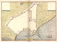 Leonardo de Ferrari's plan of the Portuguese fortifications at Tangier, c. 1655.
 -
 Hollar's landscape of Tanger at the beginning of its English occupation
 -
 Tangier c. 1901
 -
 A 1904 editorial cartoon illustrating the gunboat diplomacy involved in resolving the Perdicaris Incident.
 -
 Aerial view of Tangier in 1932
 -
 Tangier and its mid-20th-century international zone

_(14780828702).jpg)
.jpg)


Geography

Central Tangier lies about 23 km (14 mi) east of Cape Spartel,[76] the southern half of the Strait of Gibraltar.[55] It nestles between two hills at the northwest end of the Bay of Tangier, which historically formed the best natural harbour anywhere on the Moroccan coast before the increasing size of ships required anchorage to be made further and further from shore.[55] The shape of the gradually-rising underlying terrain creates the effect of the city as an amphitheatre, with the commercial district in the middle.[55] The western hill (French: La Montagne) is the site of the city's citadel or kasbah. The eastern hill forms Cape Malabata,[17] sometimes proposed as the point for a strait crossing.[77] (Years of studies have, however, made no real progress thus far.)[78]
The Marshan is a plateau about 1,189 metres (3,900 ft) long spreading west of downtown along the sea.[17]
Climate
Tangier has a mediterranean climate (Köppen Csa) with heavier rainfall than most parts of North Africa and nearby areas on the Iberian Peninsula owing to its exposed location.[79] The prevailing winds blow from the sea and have kept the site generally healthy even in earlier times with much poorer sanitation.[30] The summers are relatively hot and sunny and the winters are wet and mild. Frost is rare, although a new low of −4.2 °C (24.4 °F) was recorded in January 2005.[79]
| Climate data for Tangier (Tangier Airport) 1961–1990, extremes 1917–1963 | |||||||||||||
|---|---|---|---|---|---|---|---|---|---|---|---|---|---|
| Month | Jan | Feb | Mar | Apr | May | Jun | Jul | Aug | Sep | Oct | Nov | Dec | Year |
| Record high °C (°F) | 22.0 (71.6) |
24.1 (75.4) |
24.0 (75.2) |
29.1 (84.4) |
31.9 (89.4) |
33.5 (92.3) |
36.7 (98.1) |
38.2 (100.8) |
35.8 (96.4) |
30.4 (86.7) |
27.0 (80.6) |
24.0 (75.2) |
38.2 (100.8) |
| Mean daily maximum °C (°F) | 16.2 (61.2) |
16.8 (62.2) |
17.9 (64.2) |
19.2 (66.6) |
21.9 (71.4) |
24.9 (76.8) |
28.3 (82.9) |
28.6 (83.5) |
27.3 (81.1) |
23.7 (74.7) |
19.6 (67.3) |
17.0 (62.6) |
21.8 (71.2) |
| Daily mean °C (°F) | 12.5 (54.5) |
13.1 (55.6) |
14.0 (57.2) |
15.2 (59.4) |
17.7 (63.9) |
20.6 (69.1) |
23.5 (74.3) |
23.9 (75.0) |
22.8 (73.0) |
19.7 (67.5) |
15.9 (60.6) |
13.3 (55.9) |
17.7 (63.9) |
| Mean daily minimum °C (°F) | 8.8 (47.8) |
9.4 (48.9) |
10.1 (50.2) |
11.2 (52.2) |
13.4 (56.1) |
16.2 (61.2) |
18.7 (65.7) |
19.1 (66.4) |
18.3 (64.9) |
15.6 (60.1) |
12.2 (54.0) |
9.7 (49.5) |
13.6 (56.5) |
| Record low °C (°F) | −4.2 (24.4) |
0.8 (33.4) |
4.2 (39.6) |
5.8 (42.4) |
7.4 (45.3) |
10.2 (50.4) |
10.5 (50.9) |
14.0 (57.2) |
10.0 (50.0) |
9.0 (48.2) |
4.8 (40.6) |
−0.1 (31.8) |
−4.2 (24.4) |
| Average precipitation mm (inches) | 103.5 (4.07) |
98.7 (3.89) |
71.8 (2.83) |
62.2 (2.45) |
37.3 (1.47) |
13.9 (0.55) |
2.1 (0.08) |
2.5 (0.10) |
14.9 (0.59) |
65.1 (2.56) |
134.6 (5.30) |
129.3 (5.09) |
735.9 (28.97) |
| Average precipitation days | 11.2 | 11.4 | 10.1 | 9.3 | 6.1 | 3.7 | 0.8 | 0.8 | 3.1 | 8.0 | 11.1 | 12.0 | 87.6 |
| Average relative humidity (%) | 80 | 81 | 78 | 78 | 76 | 74 | 70 | 72 | 73 | 76 | 79 | 81 | 76 |
| Mean monthly sunshine hours | 169.2 | 166.9 | 231.7 | 251.7 | 298.9 | 306.8 | 344.0 | 330.7 | 275.6 | 238.2 | 180.6 | 166.9 | 2,960.7 |
| Source 1: NOAA[80] | |||||||||||||
| Source 2: Deutscher Wetterdienst (humidity, 1973–1993)[81] | |||||||||||||
Subdivisions
The current prefecture is divided administratively into the following:[82]
| Name | Geographic code | Type | Households | Population (2004) | Foreign population | Moroccan population | Notes |
|---|---|---|---|---|---|---|---|
| Assilah | 511.01.01. | Municipality | 6,245 | 28,217 | 66 | 28,151 | |
| Bni Makada | 511.01.03. | Arrondissement | 47,384 | 238,382 | 74 | 238,308 |
Zdroj:https://en.wikipedia.org?pojem=History_of_Tangier >Text je dostupný pod licencí Creative Commons Uveďte autora – Zachovejte licenci, případně za dalších podmínek. Podrobnosti naleznete na stránce Podmínky užití. Zdroj: Wikipedia.org - čítajte viac o History of Tangier
Text je dostupný za podmienok Creative
Commons Attribution/Share-Alike License 3.0 Unported; prípadne za ďalších
podmienok. |

