A | B | C | D | E | F | G | H | CH | I | J | K | L | M | N | O | P | Q | R | S | T | U | V | W | X | Y | Z | 0 | 1 | 2 | 3 | 4 | 5 | 6 | 7 | 8 | 9
 | |
| Continent | Europe |
|---|---|
| Region | Balkan Peninsula, Southeast Europe |
| Coordinates | 42°45′N 25°30′E / 42.750°N 25.500°E |
| Area | Ranked 103rd |
| • Total | 110,993.6[1] km2 (42,854.9 sq mi) |
| Coastline | 378 km (235 mi) |
| Borders | 1,867 km |
| Highest point | Musala,[2] 2,925 m (9,596 ft) |
| Lowest point | Black Sea, 0 m |
| Longest river | Iskar River, 368 km (229 mi) |
| Largest lake | Lake Burgas 27 km2 (10 sq mi) |
| Climate | temperate in north to Mediterranean in south |
| Terrain | mountains and hills with lowlands in north and southeast |
| Natural resources | copper, lead, zinc, coal, timber, arable land |
| Natural hazards | earthquakes (in certain areas), floods, landslides |
| Environmental issues | air and water pollution, deforestation, soil contamination[3] |
| Exclusive economic zone | 110,879 km2 (42,811 sq mi) |
Bulgaria is a country situated in Southeast Europe that occupies the eastern quarter of the Balkan peninsula, being the largest country within its geographic boundaries. It borders Romania to the north, Serbia and North Macedonia to the west, Greece and Turkey to the south, and the Black Sea to the east. The northern border with Romania follows the river Danube until the city of Silistra. The land area of Bulgaria is 110,994[1] square kilometres (42,855 sq mi) (111,002[1] square kilometres (42,858 sq mi)), slightly larger than that of Cuba, Iceland or the U.S. state of Tennessee. Considering its relatively compact territorial size and shape, Bulgaria has a great variety of topographical features. Even within small parts of the country, the land may be divided into plains, plateaus, hills, mountains, basins, gorges, and deep river valleys. The geographic center of Bulgaria is located in Uzana.
Bulgaria features notable diversity with the landscape ranging from the snow-capped peaks in Rila, Pirin and the Balkan Mountains to the mild and sunny Black Sea coast and southernmost valleys; from the typically continental Danubian Plain (ancient Moesia) in the north to the strong Mediterranean climatic influence in the valleys of Macedonia and in the lowlands in the southernmost of Thrace, the lowest parts of the Upper Thracian Plain, along the Maritsa River, the Southern Bulgarian Black Sea Coast. Most of the country is situated within the humid continental climate region, with Alpine climate in the highest mountains and subtropical climate in the southernmost regions.[4]
The country has a dense river network but with the notable exception of the river Danube, rivers are mostly short and with low water flow.[5] The average annual precipitation is 670 mm; the rainfall is lower in the lowlands and higher in the mountains. The driest region is Dobrudzha in the north-eastern part of the Danubian Plain (450 mm), while the highest rainfall has been measured in the upper valley of the river Ogosta in the western Balkan Mountains (2293 mm).[6]
Bulgaria has substantial land in agriculture and forest. In 2006 land use and land cover was 5% intensive human use, 52% agriculture including pasture, 31% forest, 11% woodland-shrub, grassland, and non-vegetated, and 1% water.[7]
Phytogeographically, Bulgaria straddles the Illyrian and Euxinian provinces of the Circumboreal Region within the Boreal Kingdom. The country falls within six terrestrial ecoregions of the Palearctic realm: Balkan mixed forests (main), Rodope montane mixed forests (main in the mountains), Euxine-Colchic deciduous forests, Aegean and Western Turkey sclerophyllous and mixed forests, East European forest steppe and Pontic–Caspian steppe.[8]
Boundaries and territory
The borders of Bulgaria have a total length of 2,245 km; of them 1,181 km are land boundary and 686 km are formed by rivers. The coastline is 378 km.[9][10]
The northern border with Romania is 609 km. Most of the frontier (470 km) is formed by the river Danube from the mouth of the river Timok in the west to the city of Silistra in the east. The land border from Silistra to Cape Sivriburun at the Black Sea is 139 km long.[9] The Danube, with steep bluffs on the Bulgarian side and a wide area of swamps and marshes on the Romanian side, is crossed by two bridges – New Europe Bridge between Vidin and Calafat, and Danube Bridge between Ruse and Giurgiu. There are 48 Bulgarian and 32 Romanian islands along the river Danube; the largest one, Belene (41 km2), belongs to Bulgaria.[11] The land frontier has three border crossings at Silistra, Kardam and Durankulak at the Black Sea. It is also crossed by a major gas pipeline transporting natural gas from Russia to Bulgaria.[11]

The eastern border (378 km) is maritime and encompasses the Bulgarian Black Sea Coast from Cape Sivriburun in the north to the mouth of the Rezovo River in the south.[11] Bulgaria's littoral forms 1/10 of the total Black Sea coastline, and includes two important gulfs, the Gulf of Varna and the Gulf of Burgas, harbouring the country's two major ports.[11]
The southern border is 752 km long, of them 259 km are with Turkey and 493 km are with Greece.[10][12] The Bulgaria–Turkey frontier runs from the mouth of the Rezovo River in the east through the Strandzha Mountains and the Dervent Heights, crosses the river Tundzha at the village of Matochina and ends at the river Maritsa at the village of Kapitan Andreevo. There are three border crossings at Malko Tarnovo, Lesovo and Kapitan Andreevo.[12] The border with Greece runs from Kapitan Andreevo through several ridges of the Rhodope Mountains, generally following the watershed of the rivers Arda and Vacha on the Bulgarian side, runs through the Slavyanka Mountain, crosses the river Struma at the village of Kulata and runs through the crest of the Belasitsa Mountain to the Tumba Peak.[12] There are six border checkpoints at Svilengrad, Ivaylovgrad, Makaza, Zlatograd, Ilinden and Kulata.[12]
The western border is 506 km long, of them 165 km are with North Macedonia and 341 km are with Serbia.[10][13] The frontier with North Macedonia runs from the Tumba Peak in the south through the mountains of Ograzhden, Maleshevo, Vlahina and Osogovo up to mount Kitka. There are three border crossings near the town of Petrich and at the villages of Logodazh and Gyueshevo.[13] The border with Serbia runs from Kitka through the mountainous region Kraishte, including the Ruy Mountain, crosses the valley of the river Nishava, runs through the main watershed of the western Balkan Mountains and follows the river Timok for 15 km until its confluence with the Danube.[13] There are five border checkpoints at Dolno Uyno, Strezimirovtsi, Kalotina, Vrashka Chuka and Bregovo.[13]
Topography

The relief of Bulgaria is varied. In the relatively small territory of the country there are extensive lowlands, plains, hills, low and high mountains, many valleys and deep gorges.[14] The main characteristic of Bulgaria's topography is four alternating bands of high and low terrain that extend east to west across the country. From north to south, those bands, called geomorphological regions, are the Danubian Plain, the Balkan Mountains, the Transitional region and the Rilo-Rhodope region. The easternmost sections near the Black Sea are hilly, but they gradually gain height to the west until the westernmost part of the country is entirely high ground.[14]
Table, showing the distribution of the height zones in Bulgaria:[15]
| Height zones | Height (m) | Area (km2) | Area (%) |
|---|---|---|---|
| Lowlands | 0–200 | 34,858 | 31.42 |
| Hills | 200–600 | 45,516 | 41.00 |
| Low mountains | 600–1000 | 16,918 | 15.24 |
| Medium-high mountains | 1000–1600 | 10,904 | 9.82 |
| High mountains | 1600–2925 | 2,798 | 2.52 |
More than two-thirds of the country is plains, plateaus, or hilly land at an altitude less than 600 m. Plains (below 200 m) make up 31% of the land, plateaus and hills (200 to 600 m) 41%, low mountains (600 to 1,000 m) 10%, medium-high mountains (1,000 to 1,500 m) 10%, and high mountains (over 1,500 m) 3%.[15] The average altitude of Bulgaria is 470 m.
The contemporary relief of Bulgaria is a result of continuous geological evolution. The Bulgarian lands were often submerged by ancient seas and lakes, some land layers rose others sank. Volcanic eruptions were common both on land and in the water basins.[15] All three main groups of rocks, magmatic, sedimentary and metamorphic, are found in the country.[14] The oldest rock formations in Bulgaria date from the Precambrian period than 500 million years ago. During the Archean, Proterozoic and Paleozoic eras (4.0 billion to 252 million years ago) the magmatic rocks were formed. Throughout most of that period the only land areas were Rila, Pirin and the western Rhodope Mountains.[16] The Mesozoic era (252 million to 66 million years ago) saw the beginning of the Alpine orogeny that has formed the mountain ranges of the Alpide belt, including the Balkan Mountains and Sredna Gora.[16] The Cenozoic era (since 66 million years ago) is characterized with active tectonic processes, the definitive formation of the Balkan Mountains, the formation of grabens and horsts in Rila, Pirin and Kraishte region.[16]
Examples of rock formations in Bulgaria:
-
 Belogradchik Rocks, western Balkan Mountains
 -
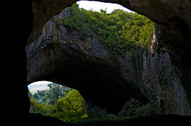 Devetashka cave, Pre-Balkan
 -
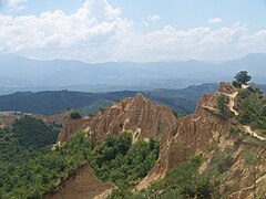 Melnik Earth Pyramids, Pirin Mountains
 -
 Pobiti Kamani, Danubian Plain
 -
 Marvelous Bridges, Rhodope Mountains


Exogenous processes such as weathering, erosion and sedimentation have an important impact on modelling the land surface and creating rock formations.[17] The exogenous processes have formed stone rivers in Vitosha; screes in the Balkan Mountains, Rila and Pirin; earth pyramids in Melnik, Stob and Katina; landslides, mainly along the Danube banks and the northern Black Sea coast; fluvial terraces; aeolian forms, such as dunes; karst forms, including numerous caves, sinkholes, ponors, etc.[18]
Danubian Plain


The Danubian Plain encompasses the Moesian plate and extends from the river Timok in the west to the Black Sea in the east and from the river Danube in the north to the Balkan Mountains in the south, covering 31,520 km2, or almost 1/3 of Bulgaria's total area.[19] Its width varies from 25 to 30 km in the west to 120 km in the east. The highest point is Tarnov Dyal (502 m) on the Shumen Plateau; the average altitude is 178 m.[20] As a result of the rock weathering processes the relief is uneven with fertile alluvial plains along the Danube (Vidinska, Chernopolska, Zlatia, Belenska, Pobrezhie, Aidemirska), and hilly terrain in the remaining area, including plateaus in the east. The altitude rises from west to east. The valleys of the rivers Vit and Yantra divide the Danubian Plain into three parts – western, central and eastern.[20] The topography of the plain is characterized with hilly heights and plateaus. Most of the heights and all plateaus are situated in the eastern parts. There are 14 basalt mounds between Svishtov and the village of Dragomirovo.[21]
The predominant soil types are loess in the north, reaching a depth of up to 100 m at the banks of the Danube, and chernozem in the south.[22] The climate is temperate. The flat relief and the openness of plain to the north facilitate arrival of moist air masses in spring, summer and autumn. In winter the Danubian Plain falls under the influence of the Eastern European anticyclone, which brings cold Arctic air masses.[22] The mean temperature in January is −1 °C and in July is 24 °C, making it the geomorphological region with the highest average annual amplitude in Bulgaria – 25 °C.[22]
Balkan Mountains

The Balkan Mountains range is a geological continuation of the Carpathian Mountains, forming part of the Alpine-Himalayan orogenic belt. This region is subdivided into two geomorphological units, the Pre-Balkan and the Balkan Mountains, also known in Bulgarian as Стара Планина – "Old Mountain". Their average altitude is 370 m and 735 m, respectively.[21] Its total area is 26,720 km2, of them the Pre-Balkan spans 15,730 km2 and the Balkan Mountains – almost 11,000 km2.[23] The mountain range stretches from the valley of the river Timok in the west to Cape Emine at the Black Sea coast in the east, spanning a length of 555 km and width between 20 and 70 km.[24] The Balkan Mountains are divided into western, central and eastern part by the Zlatitsa and Vratnik Passes.[23] The range is highest in its central part, which includes Botev Peak at 2,376 m; the altitude drops slowly to the east until it reaches the sea. The relief is varied, with many mountain passes, gorges and landforms. The southern slopes are steeper than the northern.[21] For the most part the Balkan Range defines the most important watershed in Bulgaria with rivers draining north to the Danube or south to the river Maritsa and the Aegean Sea. Several rivers in the east drain directly into the Black Sea. In the west, the river Iskar forms a 65-km long gorge that runs north through the mountains.[23]
Transitional region

The Transitional geomorphological region encompasses the territory between the Balkan Mountains and the Rilo-Rhodope Massif and has complex, mosaic relief composed mainly of medium-high and low mountains, valleys and plains. The altitude decreases from west to east.[25] This region includes the Sub-Balkan valleys; the mountains and valleys of the Kraishte region, such as Ruy Mountain, Miloslavska planina and Milevska Planina; the mountains Lyulin, Vitosha, Sredna Gora, Strandzha and Sakar; the Dervent Heights; as well as the fertile Upper Thracian Plain.[25] The highest point is Cherni Vrah in Vitosha at 2,290 m.[25]
The Sub-Balkan valleys include nine valleys, situated between the Balkan Mountains in the north and Vitosha and Sredna Gora in the south. With an area of 1,186 km2 and an average altitude of 550 m, Sofia Valley is the largest of the nine and contains the nation's capital, Sofia. The Rose Valley encompasses the valleys of Karlovo and Kazanlak and is renowned for its rose-growing industry, which has been thriving there for centuries, producing 85% of the world's rose oil.[26] The Kazanlak Valley is also known as the Valley of the Thracian Kings due to the extremely high concentration and variety of monuments of the Thracian culture.
Srednogorie region stretches between the Sub-Balkan valleys in the north and the Rilo-Rhodope Massif in the south and from west to east includes the mountains Zavalska Planina, Viskyar, Lyulin, Vitosha, Plana and Sredna Gora. The largest of these, Sredna Gora, is 280 km and reaches a maximum width of 50 km.[26] Kraishte region covers the western parts of the Transitional geomorphological region and consists of two almost parallel mountain groups, Ruysko–Verilska and Konyavsko–Milevska, as well as numerous valleys.[27]
The Upper Thracian Plain encompasses the middle valley of the river Maritsa and has a roughly triangular shape, situated between Sredna Gora in the north, the Rhodope Mountains in the south and Sakar Mountain in the east. The lowland is 180 km long and up to 50 km wide, spanning an area of 6,000 km2.[28] To the east are located the Burgas Plain, Svetliyski Heights, Manastirski Heights, Dervent Heights, and the low mountains Sakar and Strandzha.[29]
Rilo-Rhodope region

The Rilo-Rhodope geomorphological region covers the south-western regions of Bulgaria and includes the Rhodope Mountains, Rila, Pirin, Osogovo, Vlahina, Maleshevo, Ograzhden, Slavyanka and Belasitsa, as well as the valleys of the rivers Struma and Mesta.[25] The Rhodopes are the most extensive mountain range in Bulgaria, spanning an area of 14,730 km2 with an average altitude of 785 m, characterized with gentle and densely forested slopes. Their length from west to east is 249 km and reach width of 100 km.[30] The altitude decreases from west to east.[25]
To the west are located Rila and Pirin, Bulgaria's two highest mountains. Rila includes Mount Musala, whose 2,925 m peak is the highest in the Balkan Peninsula, while Pirin's highest peak Vihren at 2,915 m is the third-highest in the Balkans. Both Rila and Pirin have rocky peaks, stony slopes, extensive Alpine zone and hundreds glacial lakes.[31] Further west is the Osogovo–Belasitsa mountain group along the border with North Macedonia, whose highest peak is Ruen in Osogovo at 2,251 m.[32]
Black Sea coast

The Bulgarian Black Sea Coast has a total length of 378 km from Durankulak in the north to the mouth of the river Rezovska in the south.[33] The northernmost section between the Bulgarian-Romanian border to Shabla has extensive sandy beaches and several coastal lakes, then the elevation rises as the coast reaches Cape Kaliakra, with 70 m high vertical cliffs. Near Balchik and Kavarna the limestone rocky coast is cut by wooded valleys. The landscape around the coast resorts of Albena and Golden Sands is hilly, with a clearly expressed land slides. Dense forests at the mouth of the river Batova mark the beginning of Frangensko plateau. South of Varna the coastline is densely wooded, especially at the alluvial longose groves of the Kamchia Biosphere Reserve. Cape Emine marks the end of the Balkan Mountain and divides the Bulgarian Black Sea coast in northern and southern parts. The southern section has wide and long beaches, with a number of small bays and headlands.[33] All Bulgarian Black Sea islands are situated in the southern coast: St. Anastasia, St. Cyricus, St. Ivan, St. Peter and St. Thomas. Sandy beaches occupy 34% of the Bulgarian coastline.[34] The two most important gulf are the Gulf of Varna in the north and the Gulf of Burgas in the south, which is the largest in the Bulgarian Black Sea coast.[33]
Climate

Considering its relatively small area, Bulgaria has variable and complex climate. The country occupies the southernmost part of the continental climatic zone, with small areas in the south falling within the Mediterranean climatic zone.[35] The continental zone is predominant, because continental air masses flow easily into the unobstructed Danubian Plain. The continental influence, stronger during the winter, produces abundant snowfall; the Mediterranean influence increases during the second half of summer and produces hot and dry weather. Bulgaria is subdivided into five climatic zones: continental zone (Danubian Plain, Pre-Balkan and the higher valleys of the Transitional geomorphological region); transitional zone (Upper Thracian Plain, most of the Struma and Mesta valleys, the lower Sub-Balkan valleys); continental-Mediterranean zone (the southernmost areas of the Struma and Mesta valleys, the eastern Rhodope Mountains, Sakar and Strandzha); Black Sea zone along the coastline with an average length of 30–40 km inland; and alpine zone in the mountains above 1000 m altitude (central Balkan Mountains, Rila, Pirin, Vitosha, western Rhodope Mountains, etc.).[36]


Despite the large distance, the most important climate-forming factor is the Atlantic Ocean through the atmospheric circulation of the Icelandic cyclone and the Azores anticyclone, which bring cool and rainy weather in summer and relatively mild weather with abundant snowfall in winter.[38][39] The influence of the Mediterranean Sea is strongest in the southern parts of Bulgaria, mainly through the Mediterranean cyclones. Due to its small area, the influence of the Black Sea only affects a 30–40 km long strip along the coastline, mainly in summer, when the daily breeze circulation is most pronounced.[39][40]
Another important factor is the relief. The Bulgarian mountains and valleys act as barriers or channels for air masses, causing sharp contrasts in weather over relatively short distances. The Balkan Mountains form a barrier which effectively stops the cool air masses coming from the north and the warm masses from the south.[40] The barrier effect of the Balkan Mountains is felt throughout the country: on the average, northern Bulgaria is about one degree cooler and receives about 192 mm more rain than lowlands of southern Bulgaria. The Rilo-Rhodope Massif bars the warm Mediterranean air masses and limits the Mediterranean influence to the southern valleys of the rivers Struma, Mesta, Maritsa and Tundzha, despite the close proximity of the Aegean Sea.[39][40]
The mean annual temperature in Bulgaria is 10.6 °C and varies from 2.2 °C at the nation's highest peak Musala to 14.7 °C (1991-2021 Climate data) at the town of Sandanski in the southern Struma valley.[41] The average temperature in the Danubian Plain is 11.4 °C, in the Upper Thracian Plain 13.9 °C, in the lower mountains 8.1 °C and in the higher mountains 2.4 °C.[41] The highest absolute temperature was measured at the town of Sadovo in 1916 45.2 °C; the lowest absolute temperature was measured at the town of Tran in 1947 –38.3 °C.[39][41] The highest temperature in the lowlands and the hilly regions is in July, while in the higher mountains the warmest month is August. The lowest temperature is measured in January (Dragoman - average monthly temperature: -2, Ahtopol: + 4,2) and February , respectively.[41] Many valleys experience regular temperature inversions and fogs in winter. The country's lowest absolute temperature was measured during an inversion in the Tran valley : −38.3 °C .[40]
The average precipitation in Bulgaria is about 670 mm.[42] It is uneven in terms of seasons and territory. In northern Bulgaria the highest precipitation is in May–June, while in southern Bulgaria it is in winter. The average amount of precipitation also varies in term of altitude – from 450 to 850 mm in the plains to 850–1200 mm.[43] The lowest mean precipitation is in the eastern part of Dobrudzha and the Burgas Plain (450 mm) and in the area between Plovdiv and Pazardzhik (500 mm); the highest rainfall falls in the mountains – the Petrohan Pass in the western Balkan Mountains and Zlatograd in the Rhodope Mountains.[43] The highest annual rainfall was measured in 1957 in the upper valley of the river Ogosta in the western Balkan Mountains (2293 mm); the highest daily rainfall was recorded at Saints Constantine and Helena resort (342 mm) near Varna in 1951.[43] The total annual amount of the rainfall is 74 billion km3; of them 70% evaporate, 20% flow into the rivers and 10% soak into the soil.[43] Most of the country is affected by droughts in June and August. The snow cover lasts from 20 to 30 days in the lowlands to 9 months in the highest mountains.[43]
| Climate data for Bulgaria (records from all meteo stations) | |||||||||||||
|---|---|---|---|---|---|---|---|---|---|---|---|---|---|
| Month | Jan | Feb | Mar | Apr | May | Jun | Jul | Aug | Sep | Oct | Nov | Dec | Year |
| Record high °C (°F) | 24.8 (76.6) |
26.7 (80.1) |
35.7 (96.3) |
37.1 (98.8) |
38.8 (101.8) |
42.0 (107.6) |
45.2 (113.4) |
44.5 (112.1) |
41.9 (107.4) |
39.2 (102.6) |
32.4 (90.3) |
28.6 (83.5) |
45.2 (113.4) |
| Record low °C (°F) | −38.3 (−36.9) |
−35 (−31) |
−30.2 (−22.4) |
−20.6 (−5.1) |
−15.6 (3.9) |
−12 (10) |
−8 (18) |
−9.8 (14.4) |
−14 (7) |
−17.8 (0.0) |
−27.4 (−17.3) |
−33.5 (−28.3) |
−38.3 (−36.9) |
| Source: Stringmeteo.com,
February record high : http://eea.government.bg/bg/soer/2016/climate/climate0 November record high : https://m.dir.bg/weather/novini/s-32-4-c-veliko-tarnovo-schupi-95-godishen-natsionalen-rekord | |||||||||||||
| Climate data for Sofia (NIMH−BAS) 1991–2020 normals, extremes 1893–present | |||||||||||||
|---|---|---|---|---|---|---|---|---|---|---|---|---|---|
| Month | Jan | Feb | Mar | Apr | May | Jun | Jul | Aug | Sep | Oct | Nov | Dec | Year |
| Record high °C (°F) | 19 (66) |
23 (73) |
27.5 (81.5) |
31 (88) |
34.1 (93.4) |
38 (100) |
41 (106) |
39.4 (102.9) |
36.1 (97.0) |
33.9 (93.0) |
25.8 (78.4) |
23 (73) |
41 (106) |
| Mean daily maximum °C (°F) | 3.6 (38.5) |
6.5 (43.7) |
11.5 (52.7) |
16.7 (62.1) |
21.4 (70.5) |
25.3 (77.5) |
27.9 (82.2) |
28.4 (83.1) |
23.3 (73.9) |
17.6 (63.7) |
10.7 (51.3) |
4.6 (40.3) |
16.5 (61.6) |
| Daily mean °C (°F) | −0.5 (31.1) |
1.6 (34.9) |
5.8 (42.4) |
10.8 (51.4) |
15.5 (59.9) |
19.3 (66.7) |
21.5 (70.7) |
21.5 (70.7) |
16.8 (62.2) |
11.4 (52.5) |
5.9 (42.6) |
0.8 (33.4) |
10.9 (51.5) |
| Mean daily minimum °C (°F) | −3.8 (25.2) |
−2.3 (27.9) |
1.1 (34.0) |
5.4 (41.7) |
9.9 (49.8) |
13.4 (56.1) |
15.3 (59.5) |
15.3 (59.5) |
11.1 (52.0) |
6.7 (44.1) |
2.2 (36.0) |
−2.3 (27.9) |
6.0 (42.8) |
| Record low °C (°F) | −31.2 (−24.2) |
−25 (−13) |
−19 (−2) |
−6 (21) |
−2.2 (28.0) |
1.4 (34.5) |
2 (36) |
3.5 (38.3) |
−2 (28) |
−6 (21) |
−15.3 (4.5) |
−21.1 (−6.0) |
−31.2 (−24.2) |
| Average precipitation mm (inches) | 35.9 (1.41) |
35.5 (1.40) |
45.3 (1.78) |
52.3 (2.06) |
73.1 (2.88) |
81.6 (3.21) |
64.7 (2.55) |
53.1 (2.09) |
52.3 (2.06) |
53.9 (2.12) |
38.1 (1.50) |
39.9 (1.57) |
625.7 (24.63) |
| Average snowfall cm (inches) | 24.5 (9.6) |
20.6 (8.1) |
14.8 (5.8) |
3.1 (1.2) |
0 (0) |
0 (0) |
0 (0) |
0 (0) |
0 (0) |
1.5 (0.6) |
10.4 (4.1) |
20.7 (8.1) |
95.6 (37.5) |
| Average precipitation days | 10.2 | 9.5 | 10.9 | 10.7 | 13.8 | 10.9 | 7.7 | 7.3 | 8.7 | 9.6 | 7.1 | 10.3 | 116.7 |
| Average snowy days | 7.5 | 6.5 | 5.2 | 1.3 | 0 | 0 | 0 | 0 | 0 | 0.7 | 2.7 | 6.4 | 30.3 |
| Mean monthly sunshine hours | 87.9 | 117.2 | 169 | 195.1 | 236 | 268.1 | 311.9 | 307.3 | 225.1 | 166.8 | 107.7 | 69.1 | 2,261.2 |
| Average ultraviolet index | 1 | 2 | 4 | 5 | 7 | 9 | 9 | 8 | 6 | 4 | 2 | 1 | 5 |
| Source: Stringmeteo.com,[44][45][46][47][48] Climatebase.ru (precipitation days and extremes),[49][50] NOAA,[51] freemeteo.bg[52][53][54][55] and Weather Atlas[56] | |||||||||||||

