A | B | C | D | E | F | G | H | CH | I | J | K | L | M | N | O | P | Q | R | S | T | U | V | W | X | Y | Z | 0 | 1 | 2 | 3 | 4 | 5 | 6 | 7 | 8 | 9
Ashburton
Hakatere (Māori) | |
|---|---|
 Aerial view of Ashburton, looking west. The Ashburton River/Hakatere is visible at left. | |
| Nickname: Ashvegas | |
 Location of Ashburton | |
| Coordinates: 43°54′20″S 171°44′44″E / 43.90556°S 171.74556°E | |
| Country | New Zealand |
| Region | Canterbury |
| District | Ashburton District Council |
| Ward | Ashburton |
| Electorates |
|
| Government | |
| • Territorial authority | Ashburton District Council |
| • Regional council | Environment Canterbury |
| • Mayor of Ashburton | Neil Brown |
| • Rangitata MP | James Meager |
| • Te Tai Tonga MP | Tākuta Ferris |
| Area | |
| • Territorial | 39.99 km2 (15.44 sq mi) |
| Population (June 2023)[2] | |
| • Territorial | 20,800 |
| • Density | 520/km2 (1,300/sq mi) |
| Demonym | Ashburtonian |
| Time zone | UTC+12 (NZST) |
| • Summer (DST) | UTC+13 (NZDT) |
| Postcode(s) | |
| Postcode(s) | 7700 |
| Area code | 03 |
| Local iwi | Ngāi Tahu |
| Website | Ashburton District Council |
Ashburton (Māori: Hakatere) is a large town in the Canterbury Region, on the east coast of the South Island of New Zealand. The town is the seat of the Ashburton District. It is 85 kilometres (53 mi) south west of Christchurch and is sometimes regarded as a satellite town of Christchurch.[3]
The town has a population of 20,800.[2] It is the 29th-largest urban area in New Zealand and the fourth-largest urban area in the Canterbury Region, after Christchurch, Timaru and Rolleston.
Toponymy
Ashburton was named by the surveyor Captain Joseph Thomas of the New Zealand Land Association, after Francis Baring, 3rd Baron Ashburton, who was a member of the Canterbury Association. Ashburton is sometimes nicknamed "Ashvegas", an ironic allusion to Las Vegas.[4]
Hakatere is the traditional Māori name for the Ashburton River. The name translates as "to make swift or to flow smoothly".[5]
History
In 1858 William Turton, ran a ferry across the Ashburton river close to where the Ashburton bridge now lies. He also built an accommodation house which along with some stables were the only buildings in Ashburton in 1863.[6]
By 1864 the horse-drawn coaches of the Cobb and Co. business travelled through Ashburton between Christchurch and Timaru. This continued until the railway line was built.[7]
The town was surveyed by Robert Park in 1864.[7] It is laid out around two central squares either side of the railway line and main highway, Baring Square East and Baring Square West. The Ashburton Domain was included in the plans for the purposes of gardens and recreation. The 100 acres of land that was identified for the Domain was a "miserable wildness" of spear grass, broom, and tussock.[8]
The Canterbury provincial government granted 20,000 pounds to develop roads in the district in 1873 and in 1874 the railway reached Ashburton.[6]
The Presbyterian church was completed in 1876, The Wesleyan church in 1878 and the Catholic church in 1882.[9]
Ashburton was designated as a borough in 1878. At this stage, there were about 500 buildings within the borough.[9] A cricket pitch was established in the Ashburton Domain in 1878 and the Ashburton Hospital was established in 1879.[8]
Electricity first arrived in Ashburton in 1908. This was supplied by a 30 kilowatt generator powered by a steam traction engine. In 1921 the Ashburton Electric Power Board was established and by 1927 it had 2804 customers.[10]
Netherby was added to the borough of Ashburton in 1917, Hampstead in 1921, and Allenton in 1939 to the borough of Ashburton. In 1955, Tinwald was added to the borough.[7]
Ashburton was used as a training base for the Royal New Zealand Air Force during World War 2 with 50 tiger moth aircraft based there.[11]
On 1 September 2014, there was a violent incident in Ashburton that received nationwide publicity. A man who had previously been trespassed from the Ashburton Work and Income office arrived at the premises with a shotgun and murdered two front counter workers. At the subsequent trial, the offender was given the third longest sentence on record.[12] In the aftermath of the attack, the security at WINZ offices was reviewed nationwide.[13][14] In December 2016, the Ministry for Social Development was convicted of breaching workplace safety legislation in relation to the incident.[15]
In 2021, the Ashburton slogan: "Whatever it takes" was scrapped by the Ashburton District Council.[16] Having been in use for approximately 10 years,[17] it has drawn criticism.[18] In 2012, it made a list of Top 10 worst NZ city slogans.[19] The Ashburton welcome sign had been changed surreptitiously at times from ‘Ashburton: Whatever it Takes’ to ‘Ashburton: ‘Whatever’.[20]
In April 2021, a contract was signed to start a $42 million build of a new library and civic centre for Ashburton. A $20 million contribution came from the New Zealand government.[21][22] The three-story building will include council chambers, office space, a recording studio, areas to study in, a library and a performance area.[23] It will also incorporate the Pioneer Hall into the facility.[22] The library is to be named Te Pātaka o kā Tuhituhi and the civic centre is to be named Te Waharoa a Hine Paaka.[24]
A new retail centre called "River Crossing" is planned to open in 2022. Local property developers hope that this will mean the local people will have more opportunities to spend their money in Ashburton rather than Christchurch or Timaru. A March 2020 report found that 32% of retail spending by locals, was spent out of town. Between 150 and 180 jobs are expected to be created as a result of the development.[25]
Geography

Setting
Ashburton is situated 17 kilometres inland on the Canterbury Plains approximately 86 kilometres (53 mi) south of Christchurch and 75 kilometres north of Timaru. Methven is 33 kilometres inland from Ashburton. Rakaia and the Rakaia river are 28 kilometres to the north of Ashburton.
The town is the centre of an agricultural and pastoral farming district on the Canterbury Plains. It has one large suburb, Tinwald, south of the Ashburton River / Hakatere. The town has three other suburbs: Allenton, Hampstead and Netherby.[26]
Climate
On the whole, Ashburton shares a similar climate to Christchurch i.e. a dry temperate climate (Cfb). However, since it lies further inland at a higher altitude to Christchurch, Ashburton experiences a greater range of temperatures. During summer Ashburton can exceed 30 °C (86 °F), whilst winter can drop daily low temperatures below 1°C in the coldest month. Winter can also see regular frosts and rarely any snowfall. Ashburton's heaviest snowfall was 38 centimetres (15 in) on 12 June 2006,[27] conversely it is tied with Timaru for New Zealand's fourth-highest temperature on record, reaching 41.3 °C (106.3 °F) on 7 February 1973.[28]
| Climate data for Ashburton | |||||||||||||
|---|---|---|---|---|---|---|---|---|---|---|---|---|---|
| Month | Jan | Feb | Mar | Apr | May | Jun | Jul | Aug | Sep | Oct | Nov | Dec | Year |
| Mean daily maximum °C (°F) | 23.7 (74.7) |
23.0 (73.4) |
21.0 (69.8) |
17.9 (64.2) |
13.9 (57.0) |
11.2 (52.2) |
10.7 (51.3) |
12.3 (54.1) |
15.2 (59.4) |
18.0 (64.4) |
19.9 (67.8) |
22.0 (71.6) |
17.4 (63.3) |
| Mean daily minimum °C (°F) | 11.1 (52.0) |
10.8 (51.4) |
9.5 (49.1) |
6.4 (43.5) |
3.4 (38.1) |
0.9 (33.6) |
0.5 (32.9) |
1.8 (35.2) |
3.8 (38.8) |
6.0 (42.8) |
7.9 (46.2) |
9.9 (49.8) |
6.0 (42.8) |
| Average precipitation mm (inches) | 58.5 (2.30) |
53.6 (2.11) |
62.5 (2.46) |
65.5 (2.58) |
61.6 (2.43) |
51.1 (2.01) |
62.7 (2.47) |
66.1 (2.60) |
43.7 (1.72) |
56.6 (2.23) |
57.8 (2.28) |
56.2 (2.21) |
696.2 (27.41) |
| Source: NIWA Science climate data[29] | |||||||||||||
Rivers and lakes
The Ashburton River / Hakatere flows across Mid Canterbury from the Southern Alps to the Pacific Ocean. The official name of the river was amended to become a dual name by the Ngāi Tahu Claims Settlement Act 1998.[30] The river passes through the town of Ashburton, separating the south-east suburb of Tinwald from the rest of the town.
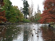
The nearest beach to Ashburton is Wakanui beach, but is not safe for swimming due to a strong undertow.[31] In part to rectify the limitations imposed by the lack of recreational waterways, Lake Hood was constructed just south-east of Tinwald. The Ashburton lakes Lake Heron, Lake Camp and Lake Clearwater are inland. On the road to these lakes are Mount Somers and the Mount Somers walkway.
Governance
Ashburton District Council is the territorial authority for the Ashburton District of New Zealand.[32] The council is led by the mayor of Ashburton, who is currently Neil Brown. There are also nine ward councillors.[32]
Demographics
Ashburton is described by Statistics New Zealand as a medium urban area, and covers 39.99 km2 (15.44 sq mi).[1] It had an estimated population of 20,800 as of June 2023,[2] with a population density of 520 people per km2.
The population of Ashburton was recorded as 2,322 in the 1901 census,[9] 8,287 in the 1951 census, 10,176 in the 1956 census and 11,604 in the 1961 census.[7]
| Year | Pop. | ±% p.a. |
|---|---|---|
| 2006 | 16,188 | — |
| 2013 | 17,883 | +1.43% |
| 2018 | 19,284 | +1.52% |
| Source: [33] | ||
Before the 2023 census, Ashburton had a smaller boundary, covering 37.93 km2 (14.64 sq mi).[1] Using that boundary, it had a population of 19,284 at the 2018 New Zealand census, an increase of 1,401 people (7.8%) since the 2013 census, and an increase of 3,096 people (19.1%) since the 2006 census. There were 7,644 households, comprising 9,531 males and 9,747 females, giving a sex ratio of 0.98 males per female, with 3,642 people (18.9%) aged under 15 years, 3,330 (17.3%) aged 15 to 29, 7,977 (41.4%) aged 30 to 64, and 4,338 (22.5%) aged 65 or older.
Ethnicities were 82.9% European/Pākehā, 9.1% Māori, 7.7% Pasifika, 5.8% Asian, and 1.6% other ethnicities. People may identify with more than one ethnicity.
The percentage of people born overseas was 17.0, compared with 27.1% nationally.
Although some people chose not to answer the census's question about religious affiliation, 43.0% had no religion, 46.8% were Christian, 0.7% had Māori religious beliefs, 0.8% were Hindu, 0.3% were Muslim, 0.4% were Buddhist and 1.3% had other religions.
Of those at least 15 years old, 1,626 (10.4%) people had a bachelor's or higher degree, and 4,239 (27.1%) people had no formal qualifications. 2,058 people (13.2%) earned over $70,000 compared to 17.2% nationally. The employment status of those at least 15 was that 7,638 (48.8%) people were employed full-time, 2,328 (14.9%) were part-time, and 429 (2.7%) were unemployed.[33]
| Name | Area (km2) |
Population | Density (per km2) |
Households | Median age | Median income |
|---|---|---|---|---|---|---|
| Allenton North | 2.10 | 2,547 | 1,213 | 1,008 | 47.7 years | $34,900[34] |
| Allenton South | 2.93 | 2,121 | 724 | 813 | 36.0 years | $33,700[35] |
| Allenton East | 1.24 | 2,121 | 1,710 | 852 | 45.3 years | $33,100[36] |
| Ashburton Central | 2.56 | 141 | 55 | 66 | 53.6 years | $31,100[37] |
| Ashburton East | 0.78 | 1,749 | 2,242 | 756 | 45.7 years | $25,700[38] |
| Ashburton North | 20.65 | 1,050 | 51 | 378 | 48.3 years | $36,400[39] |
| Ashburton West | 0.45 | 957 | 2,127 | 447 | 57.8 years | $27,200[40] |
| Hampstead | 1.44 | 2,910 | 2,021 | 1,149 | 35.7 years | $30,100[41] |
| Netherby | 1.09 | 2,130 | 1,954 | 789 | 36.0 years | $33,100[42] |
| Tinwald North | 1.90 | 1,185 | 624 | 489 | 43.5 years | $34,800[43] |
| Tinwald South | 2.75 | 2,373 | 863 | 897 | 40.4 years | $31,900[44] |
| New Zealand | 37.4 years | $31,800 |
Economy
The economy of Ashburton is influenced by the economy of the Ashburton District as a whole. In the year to March 2020, the gross domestic product (GDP) of Ashburton District was $2,506M, representing 0.8% of New Zealand's total GDP. The largest proportion of the Ashburton District GDP is derived from primary industries, at 27.0%. This is substantially higher than the 6.2% contribution of primary industries to the national GDP. The next highest contribution to the district GDP was from 'Other services' representing 26.7% in the district GDP, versus 34.7% in the national economy. Goods-producing industries were 21.3%, versus 18.7% in the national economy. High-value services (such as knowledge-based service industries) represented the smallest proportion in Ashburton District GDP, at 10.2%, versus 25.6% in the national economy.[45]
The town has businesses providing a wide range of services to farming in the district, including seed merchants, livestock companies, farm machinery dealers, banks, lawyers and accountants.[46]
Agriculture
Ashburton lies in the middle of the fertile alluvial Canterbury Plains which permits agricultural activity such as dairying, provided irrigation is used. More than 100 local farmers grow potatoes, corn and peas which are processed locally.[47]
The Ashburton District Council has a 40% holding in the company that manages the Rangitata Diversion Race.[48] This scheme diverts water from the Rangitata and South Ashburton rivers into a canal that provides irrigation to large parts of the district.
Vegetable processing
A vegetable processing factory owned by Talley's is located on the northern outskirts of Ashburton. The factory was built in 1996 to take advantage of the good soils and irrigation of the Ashburton district. The factory processes peas, corn and potatoes. The potatoes are made into French fries, hash browns and wedges. Much of what is processed is exported to overseas customers. The factory employs 360 staff.[47]
Meat processing
Ashburton was home to a lamb processing works from the early 1900s until 2017, when it was closed with the loss of 370 staff due to declining lamb numbers in Canterbury.[49] The pelt house closed in 2019 with the loss of a further 44 staff.[50] Talley's purchased the site in 2020 and had plans to use it to support vegetable production and use the cool stores for their frozen produce.[51]
Cooperative companies
In 2012, Ashburton was noted for having more cooperative companies operating in its district than in any other area of New Zealand, and was subsequently named by the New Zealand Cooperatives Association the "Cooperative Capital of New Zealand". Several of the 40-plus companies are national companies based outside the district, such as Fonterra, Foodstuffs and Silver Fern Farms (meat processing), but many were local cooperatives, such as the Ashburton Trading Society (farm supplies) and Electricity Ashburton (electricity distribution).[52]
Culture

Museum and Art Gallery
The Ashburton Museum and Art Gallery share one building, which sits on State Highway 1, just outside the centre of town. As well as temporary exhibitions, the museum has a permanent exhibition tracing the history of the Ashburton district.[53]
When the art gallery opened in 2015, it was unable to display any art works on the walls as the new air-conditioning unit, being delivered from Italy had not arrived. The 2700 art works in the collection had to remain in storage.[54]
Marae
The Hakatere marae is located on the northern edge of Ashburton. Although Ashburton is within the rohe or region where the Ngāi Tahu iwi are traditionally based, the Hakatere marae is not a Ngāi Tahu marae. It was built as a marae for people from all iwi. The marae is located on land that was originally the Fairton Primary School. This land was acquired in 1970 and the Hakatere marae was gazetted as a Māori reserve in 1976. The wharenui was destroyed by an arson attack in 2003. The wharekai was completed in 2007 at a cost of around $300,000.[5][55]
Attractions and amenities
Ashburton Domain
The Ashburton Domain sits in the centre of Ashburton next to state highway 1. At 37 hectares in size, it includes public gardens, cricket pitches, football fields, tennis courts, bowls club and a croquet club. A playground and paddling pool also have been built in the domain.[56][57]
Railway museum
The Plains Vintage Railway and Historical Museum is located in the Tinwald Domain. The railway runs on approximately three kilometres of rural railway line that was once part of the Mount Somers Branch. There are a variety of historical buildings and trains on display.[58]
Ashburton Aviation Museum
The Ashburton Aviation Museum is located at the Ashburton Airport. The museum has two buildings which display almost thirty aircraft.[59] These include a Skyhawk formerly used by the New Zealand Air Force, a Vampire FB5 and a Canberra B2 Bomber.[60] The collection also includes the only British Aerospace HS Harrier "Jump-jet" GR3 in the southern hemisphere.[61]
-
 Ashburton Aviation Museum (2023)
 -
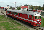 Vulcan Railcar on exhibition at the railway museum
 -
 Ashburton Domain


Notable buildings
Zdroj:https://en.wikipedia.org?pojem=Ashburton,_New_Zealand>Text je dostupný pod licencí Creative Commons Uveďte autora – Zachovejte licenci, případně za dalších podmínek. Podrobnosti naleznete na stránce Podmínky užití.
Text je dostupný za podmienok Creative
Commons Attribution/Share-Alike License 3.0 Unported; prípadne za ďalších
podmienok.
Podrobnejšie informácie nájdete na stránke Podmienky
použitia.

