A | B | C | D | E | F | G | H | CH | I | J | K | L | M | N | O | P | Q | R | S | T | U | V | W | X | Y | Z | 0 | 1 | 2 | 3 | 4 | 5 | 6 | 7 | 8 | 9
Central Jersey | |
|---|---|
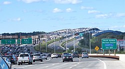
 With 15 travel lanes and six shoulder lanes, Driscoll Bridge on the Garden State Parkway in Central Jersey is one of the world's widest and busiest motor vehicle bridges; the bridge crosses Raritan River near Raritan Bay.[1] | |
| Country | United States |
| State | New Jersey |
| Largest municipalities by population | Elizabeth Lakewood Woodbridge Township Edison Hamilton Trenton Middletown Township Old Bridge Township Franklin Township Union Piscataway New Brunswick Perth Amboy Howell Township Plainfield |
| Population (2020) | 3,580,999 |
Central Jersey, or Central New Jersey, is the middle region of the U.S. state of New Jersey. The designation Central Jersey is a distinct administrative toponym.[2][3] While New Jersey is often divided into North Jersey and South Jersey, many residents recognize Central Jersey as a distinct third entity.[4] As of the 2020 census, Central Jersey has a population of 3,580,999.
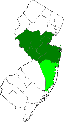
Many descriptions of Central Jersey include Middlesex County, the population center of New Jersey, and tend to include much of nearby Monmouth, Mercer, Somerset, and Hunterdon counties. The inclusion of adjacent areas of Union and Ocean are a source of debate.[5][6][7] In 2015, New Jersey Business magazine defined Central Jersey more narrowly as the five counties of Hunterdon, Mercer, Middlesex, Monmouth and Somerset.[8]
In 2022, legislation was proposed in the New Jersey Legislature to establish distinct geographic areas for tourism in the state. Bill A4711 was sponsored by Assemblymembers Roy Freiman, Sadaf Jaffer, and Anthony Verrelli in the New Jersey General Assembly.[9] This included an official designation of the region of Central Jersey, which the legislation defines more broadly as the seven counties of Hunterdon, Mercer, Middlesex, Monmouth, Ocean, Somerset, and Union.[10][11] The New Jersey Senate version of this legislation passed by a vote of 36-1 on June 20, 2023.[12] On August 24, 2023, Gov. Murphy signed legislation officially designating Central Jersey including, at a minimum, the counties of Hunterdon, Mercer, Middlesex, and Somerset.[13]
The intersection of the two busiest highways in New Jersey, the New Jersey Turnpike and the Garden State Parkway, are located in Woodbridge in Central Jersey.[14]
Trenton, the seat of Mercer County and the state capital of New Jersey, is located in the region. New Jersey's geographic center is in Hamilton Township in Mercer County. In 2011, the population center of the state was in the western portion of East Brunswick.[15]
Geographic area


The region lies roughly at the geographic heart of the Northeast megalopolis and is wholly in the New York metropolitan area, the nation's largest metropolitan area.
The Delaware Valley is another area that is associated with some parts of Central Jersey, specifically Mercer County. Yet despite the County’s close geographic proximity to Philadelphia's combined statistical area, Mercer County is considered part of the New York Combined Metropolitan Statistical Area as defined by the United States Census Bureau.[16][17][18] Some but not all regions of Hunterdon County associate themselves with the Delaware Valley and the Philadelphia metropolitan area.
The Raritan Valley is the region along the middle reaches of the Raritan River and its North Branch and South Branch. The Raritan Valley includes the communities of Branchburg, Bridgewater, Somerville, Raritan, Hillsborough, Franklin, Green Brook, North Plainfield, Bound Brook, and South Bound Brook, all in Somerset County; Dunellen, Middlesex, Piscataway, South Plainfield, Highland Park, New Brunswick, East Brunswick, Edison, and Metuchen, all in the northern and central portions of Middlesex County; and Plainfield in southwestern Union County.[19][20][21][22][23]
The Raritan Bayshore is used to describe the region in Middlesex and Monmouth Counties, located along the coastline of the Raritan Bay, from the mouth of the Raritan River in the west to the barrier island of Sandy Hook bordering the Atlantic Ocean in the east.[24] The Raritan Bayshore includes the communities of Sayreville, Woodbridge, Perth Amboy, South Amboy, and Old Bridge, all in northeastern Middlesex County; Aberdeen, Matawan, Keyport, Union Beach, Hazlet, Keansburg, Holmdel, Middletown, Atlantic Highlands, and Highlands, all in northern Monmouth County.[25][26]
The telephone area codes 732 and 848 includes Middlesex, Monmouth, Somerset, Union, and northern Ocean counties. While area codes 609 and 640 includes southern Ocean, Hunterdon, and Somerset counties, as well as Mercer County.[27]
Colonial era

Between 1674 and 1702, in the early part of New Jersey's colonial period, the border between West Jersey and East Jersey ran diagonally across the middle part of the state. The Keith Line, as the demarcation is known, ran through the center of what is now Mercer County.[28] This border remained important in determining ownership and political boundaries until 1745. Remnants of that division are seen today, notably as the Hunterdon-Somerset, Ocean-Burlington, and Monmouth-Burlington county lines.[29] The division of the two provinces was cultural as well as geographical.[30]
New Jersey's position between the major cities of New York and Philadelphia led Benjamin Franklin to call the state "a barrel tapped at both ends".[31][32] Travel between the two cities originally included a ferry crossing.
Due to the obstacles created by the Meadowlands and the Hudson Palisades, passengers from New York would cross the North River and the Upper New York Bay by boat and then transfer to stagecoaches to travel overland through what is now Central Jersey. One route from Elizabethtown to Lambertville was known as Old York Road. Another route, from Perth Amboy through Kingston to Burlington, ran along a portion of the Kings Highway, These roads followed Lenape paths known respectively as the Naritcong Trail and the Assunpink Trail.
Raritan Landing, across from New Brunswick in today's Piscataway, became an important inland port and commercial hub for the region.[33] Two of the nine Colonial Colleges, founded before the American Revolution, were the College of New Jersey (now Princeton University), and Queens College (now Rutgers University).
Population
| 2017 Rank | Municipality | County | Population in
2017 |
Population in
2010 |
Municipal
Type |
|---|---|---|---|---|---|
| 1 | Elizabeth | Union | 130,215 | 124,969 | City |
| 2 | Lakewood Township | Ocean | 102,682 | 92,843 | Township |
| 3 | Edison | Middlesex | 102,450 | 99,967 | Township |
| 4 | Woodbridge Township | Middlesex | 101,965 | 99,585 | Township |
| 5 | Toms River | Ocean | 93,017 | 91,239 | Township |
| 6 | Hamilton Township | Mercer | 89,078 | 88,464 | Township |
| 7 | Trenton | Mercer | 84,964 | 84,913 | City |
| 8 | Brick Township | Ocean | 75,516 | 75,072 | Township |
| 9 | Old Bridge Township | Middlesex | 67,032 | 65,375 | Township |
| 10 | Franklin Township | Somerset | 66,734 | 62,300 | Township |
| 11 | Middletown Township | Monmouth | 65,603 | 66,522 | Township |
| 12 | Union Township | Union | 59,327 | 56,642 | Township |
| 13 | Piscataway | Middlesex | 57,887 | 56,044 | Township |
| 14 | New Brunswick | Middlesex | 57,073 | 55,181 | City |
| 15 | Jackson Township | Ocean | 57,073 | 54,856 | Township |
| 16 | Perth Amboy | Middlesex | 52,823 | 50,814 | City |
| 17 | Howell Township | Monmouth | 52,476 | 51,075 | Township |
| 18 | Plainfield | Union | 51,327 | 49,908 | City |
| 19 | East Brunswick | Middlesex | 48,840 | 47,512 | Township |
| 20 | South Brunswick | Middlesex | 46,561 | 43,417 | Township |
| 21 | Bridgewater Township | Somerset | 45,414 | 44,464 | Township |
| 22 | Monroe Township | Middlesex | 45,332 | 39,132 | Township |
| 23 | Sayreville | Middlesex | 45,325 | 42,704 | Borough |
| 24 | Manchester Township | Ocean | 43,495 | 43,070 | Township |
| 25 | Linden | Union | 43,056 | 40,499 | City |
| 26 | North Brunswick | Middlesex | 42,641 | 40,742 | Township |
| 27 | Berkeley Township | Ocean | 41,747 | 41,255 | Township |
| 28 | Marlboro Township | Monmouth | 40,306 | 40,191 | Township |
| 29 | Manalapan Township | Monmouth | 40,013 | 38,872 | Township |
| 30 | Hillsborough Township | Somerset | 40,003 | 38,303 | Township |
| 31 | Ewing Township | Mercer | 36,549 | 35,790 | Township |
| 32 | Freehold Township | Monmouth | 35,053 | 36,184 | Township |
| 33 | Lawrence Township | Mercer | 33,161 | 33,472 | Township |
| 34 | Long Branch | Monmouth | 30,762 | 30,719 | City |
| 35 | Westfield | Union | 30,433 | 30,316 | Town |
| 36 | Lacey Township | Ocean | 30,131 | 27,346 | Township |
| Rank | County | Population | County Seat | Area |
|---|---|---|---|---|
| 1 | Middlesex | 829,685 | New Brunswick | 311 sq mi
(805 km2) |
| 2 | Monmouth | 621,354 | Freehold Borough | 472 sq mi
(1,222 km2) |
| 3 | Ocean | 601,651 | Toms River | 636 sq mi
(1,647 km2) |
| 4 | Union | 558,067 | Elizabeth | 103 sq mi
(267 km2) |
| 5 | Mercer | 369,811 | Trenton | 226 sq mi
(585 km2) |
| 6 | Somerset | 331,164 | Somerville | 305 sq mi
(790 km2) |
| 7 | Hunterdon | 124,714 | Flemington | 430 sq mi
(1,114 km2) |
Economy

>Text je dostupný pod licencí Creative Commons Uveďte autora – Zachovejte licenci, případně za dalších podmínek. Podrobnosti naleznete na stránce Podmínky užití.
Text je dostupný za podmienok Creative
Commons Attribution/Share-Alike License 3.0 Unported; prípadne za ďalších
podmienok.
Podrobnejšie informácie nájdete na stránke Podmienky
použitia.

