A | B | C | D | E | F | G | H | CH | I | J | K | L | M | N | O | P | Q | R | S | T | U | V | W | X | Y | Z | 0 | 1 | 2 | 3 | 4 | 5 | 6 | 7 | 8 | 9
Chester County | |
|---|---|
| County of Chester | |
 | |
 Flag  Seal | |
 Location within the U.S. state of Pennsylvania | |
 Pennsylvania's location within the U.S. | |
| Coordinates: 39°58′N 75°45′W / 39.97°N 75.75°W | |
| Country | |
| State | |
| Founded | August 24, 1682 |
| Named for | Chester, England |
| Seat | West Chester |
| Largest city | West Chester |
| Government | |
| • County commission | |
| Area | |
| • Total | 759 sq mi (1,970 km2) |
| • Land | 751 sq mi (1,950 km2) |
| • Water | 8.7 sq mi (23 km2) 1.1%% |
| Population (2020) | |
| • Total | 534,413 |
| • Density | 712.0/sq mi (274.9/km2) |
| Time zone | UTC−5 (Eastern) |
| • Summer (DST) | UTC−4 (EDT) |
| Congressional districts | 5th, 6th |
| Website | www |
| Designated | October 26, 1982[1] |

Chester County (Pennsylvania Dutch: Tscheschter Kaundi), colloquially known as Chesco, is a county in the southeastern part of the U.S. state of Pennsylvania. As of the 2020 census, the population was 534,413,[2] increasing by 7.1% from 498,886 in 2010.[3] The county seat and most populated municipality is West Chester.[4] Chester County was one of the three original Pennsylvania counties created by William Penn in 1682. It was named for Chester, England.
Chester County is part of the Philadelphia-Camden-Wilmington, PA-NJ-DE-MD Metropolitan Statistical Area. Eastern Chester County is home to many communities that comprise part of the Main Line western suburbs outside of Philadelphia, while part of its southernmost portion is considered suburban Wilmington, along with southwest Delaware County.
History

Philadelphia, Bucks, and Chester were the three Pennsylvania counties initially created by William Penn on August 24, 1682.[5][6] At that time, Chester County's borders were Philadelphia County to the north, the ill-defined western edge of the colony (approximately the Susquehanna River) to the west, the Delaware River to the east, and Delaware and Maryland to the south. Chester County replaced the Pennsylvania portion of New Netherland/New York’s "Upland", which was officially eliminated when Pennsylvania was chartered on March 4, 1681, but did not cease to exist until June of that year.[7][8] Much of the Welsh Tract was in eastern Chester County, and Welsh place names, given by early settlers, continue to predominate there.
The fourth county in the state, Lancaster County, was formed from Chester County on May 10, 1729. On March 11, 1752, Berks County was formed from the northern section of Chester County, as well as parts of Lancaster and Philadelphia counties.
The original Chester County seat was the City of Chester, a center of naval shipbuilding, at the eastern edge of the county. In an effort to accommodate the increased population of the western part of the county, the county seat was moved to a more central location in 1788; in order to mollify the eastern portion of the county, the village, known as Turk's Head, was renamed West Chester. In response to the new location of the county seat, the eastern portion of the county separated and formed the new Delaware County in 1789 with the City of Chester as its county seat.[9]
Much of the history of Chester County arises from its location between Philadelphia and the Susquehanna River. The first road to "the West" (meaning Lancaster County) passed through the central part of Chester County, following the Great Valley westward; with some re-alignments, it became the Lincoln Highway and later U.S. Route 30. This road is still named Lancaster Avenue in most of the Chester County towns it runs through. The first railroad (which became the Pennsylvania Railroad) followed much the same route, and the Reading Railroad progressed up the Schuylkill River to Reading. Industry tended to concentrate along the rail lines. Easy transportation allowed workers to commute to urban jobs, and the rise of the suburbs followed. To this day, the developed areas form "fingers" extending along major lines of transportation.
During the American Revolutionary War, the Battle of Brandywine was fought at what is now the southeastern fringe of the county. The Valley Forge encampment was at the northeastern edge.
Geography
According to the U.S. Census Bureau, the county has a total area of 759 square miles (1,970 km2), of which 751 square miles (1,950 km2) is land and 8.7 square miles (23 km2) (1.1%) is water.[10] The topography consists of rolling hills and valleys and it is part of the region known as the Piedmont.
Watersheds that serve Chester County include the Octoraro, the Brandywine, and Chester creeks, and the Schuylkill River. Many of the soils are fertile, rich loam as much as twenty-four inches thick; together with the temperate climate, this was long a major agricultural area.[citation needed] Because of its proximity to Philadelphia, Chester County has seen large waves of development over the past half-century due to suburbanization. Although development in Chester County has increased, agriculture is still a major part of the county's economy, and the number of horse farms is increasing in the county.[citation needed] Mushroom growing is a specialty in the southern portion of the county.
Elevations (in feet): High point—1020 Welsh Mt., Honeybrook Twp. Other high points—960 Thomas Hill, Warwick Twp; 960 Barren Hill, West Caln Twp. Low point—66 Schuylkill River, Chester-Montgomery county line. Cities and boroughs: Coatesville 314; Downingtown 255; Kennett Square 300; Oxford 535; Parkesburg 542; Phoenixville 127; Spring City 114; West Chester 459.[11]
Adjacent counties
- Berks County (north)
- Montgomery County (northeast)
- Delaware County (east)
- New Castle County, Delaware (southeast)
- Cecil County, Maryland (south)
- Lancaster County (west)
National protected area
State protected areas
Major roads and highways
Economy and environment
Lanchester Landfill, located on the border of Chester and Lancaster Counties, captures methane which is sold for renewable natural gas credits, and piped to seven local businesses. This reduces the county's methane emissions, and provides an alternative to fracking for shale gas.[12] In addition, several companies have their headquarters or a major presence in the county including Bentley Systems, EBS Healthcare, Main Line Health, Lavazza North America (formerly Mars Drinks), Depuy Synthes (part of Johnson & Johnson), Metabo, QVC, Hankin Group, Axalta Coating Systems, CTDI, Pactiv, Ricoh Americas, Blinding Edge Pictures, AmerisourceBergen, J.G. Wentworth, The Vanguard Group, and Victory Brewing Company among others.
Demographics
| Historical population | |||
|---|---|---|---|
| Census | Pop. | %± | |
| 1790 | 27,829 | — | |
| 1800 | 32,093 | 15.3% | |
| 1810 | 39,596 | 23.4% | |
| 1820 | 44,451 | 12.3% | |
| 1830 | 50,910 | 14.5% | |
| 1840 | 57,515 | 13.0% | |
| 1850 | 66,438 | 15.5% | |
| 1860 | 74,578 | 12.3% | |
| 1870 | 77,805 | 4.3% | |
| 1880 | 83,481 | 7.3% | |
| 1890 | 89,377 | 7.1% | |
| 1900 | 95,695 | 7.1% | |
| 1910 | 109,213 | 14.1% | |
| 1920 | 115,120 | 5.4% | |
| 1930 | 126,629 | 10.0% | |
| 1940 | 135,626 | 7.1% | |
| 1950 | 159,141 | 17.3% | |
| 1960 | 210,608 | 32.3% | |
| 1970 | 278,311 | 32.1% | |
| 1980 | 316,660 | 13.8% | |
| 1990 | 376,396 | 18.9% | |
| 2000 | 433,501 | 15.2% | |
| 2010 | 498,886 | 15.1% | |
| 2020 | 534,413 | 7.1% | |
| U.S. Decennial Census[13] 1790-1960[14] 1900-1990[15] 1990-2000[16] 2010-2019[3] | |||
As of the 2010 census, the county was 82.1% White Non-Hispanic, 6.1% Black or African American, 0.2% Native American or Alaskan Native, 3.9% Asian, 0.0% Native Hawaiian, 1.8% were two or more races, and 2.4% were some other race. 6.5% of the population were Hispanic or Latino.
As of the census[17] of 2000, there were 433,501 people, 157,905 households, and 113,375 families residing in the county. The population density was 573 people per square mile (221/km2). There were 163,773 housing units at an average density of 217 per square mile (84/km2). The racial makeup of the county was 89.21% White, 6.24% Black or African American, 0.15% Native American, 1.95% Asian, 0.03% Pacific Islander, 1.35% from other races, and 1.06% from two or more races. 3.72% of the population were Hispanic or Latino of any race. 18.0% were of Irish, 17.3% German, 13.1% Italian, 10.1% English and 5.6% American ancestry. 91.4% spoke English and 3.7% Spanish as their first language.
There were 157,905 households, out of which 35.10% had children under the age of 18 living with them, 60.50% were married couples living together, 8.10% had a female householder with no husband present, and 28.20% were non-families. 22.60% of all households were made up of individuals, and 7.60% had someone living alone who was 65 years of age or older. The average household size was 2.65 and the average family size was 3.15.
In the county, the population was spread out, with 26.20% under the age of 18, 7.90% from 18 to 24, 30.40% from 25 to 44, 23.80% from 45 to 64, and 11.70% who were 65 years of age or older. The median age was 37 years. For every 100 females there were 96.40 males. For every 100 females age 18 and over, there were 93.10 males.
The median income for a household in the county was $65,295, and the median income for a family was $76,916 (these figures had risen to $80,818 and $97,894 respectively as of a 2007 estimate). Males had a median income of $51,223 versus $34,854 for females. The per capita income for the county was $31,627. About 3.10% of families and 5.20% of the population were below the poverty line, including 5.10% of those under age 18 and 5.50% of those age 65 or over.
The region was originally occupied by the Lenni Lenape people, who greeted European settlers in the seventeenth century with amity and kindness. British settlers were mostly English, Scotch-Irish and Welsh in ethnicity. From the late 19th to early 20th century, the industrial areas of the region, such as Coatesville, attracted immigrants and job seekers from Germany and Ireland, Eastern Europe, Italy, and the American rural South, with both black and white migrants coming north. Later Hispanic immigrants have included Puerto Ricans and, most recently, Mexicans.
Long a primarily rural area, Chester County is now[when?] the fastest-growing county in the Delaware Valley; it is one of the fastest growing in the entire Northeastern section of the United States.
Religion

In keeping with its colonial history, Chester County is home to a number of historic Quaker buildings, including Birmingham, Birmingham Orthodox, Bradford, Caln, Old Kennett, Parkersville, Westtown, and Uwchlan meeting houses. Other historic religious buildings include St. Malachi Church, southeastern Pennsylvania's oldest active Catholic mission church, and the Episcopal St. Mary's, St. Paul's, and St. Peter's churches, and Washington Memorial Chapel. Also located in the county are the First Presbyterian Church of West Chester, Coventryville United Methodist Church, which is part of the Coventryville Historic District, and Beth Israel Congregation of Chester County, a Conservative synagogue in Coatesville, a site of Eastern European immigration in the 20th century.
Politics
Voter registration
According to the Secretary of State's office, Democrats comprise a plurality of registered voters in Chester County.
| Chester County voter registration statistics as of November 1, 2021[18] | |||||
|---|---|---|---|---|---|
| Political Party | Total Voters | Percentage | |||
| Democratic | 154,920 | 41.65% | |||
| Republican | 149,859 | 40.29% | |||
| No Party Affiliation | 44,373 | 11.93% | |||
| Third Parties | 22,831 | 6.14% | |||
| Total | 371,983 | 100.00% | |||
Election results

Chester County has historically been reliably Republican at the county level; traditionally, it was the most conservative county in the Philadelphia area. In recent elections, however, it has been trending Democratic, though not as overwhelmingly as the rest of the Philadelphia suburbs. In 2000 Al Gore lost it by almost 10 percent but in 2004 George W. Bush defeated John Kerry by a much smaller margin of only 4.5 percent. Bob Casey, Jr. carried it by 10% when he unseated incumbent Republican US Senator Rick Santorum in 2006. In 2008, Chester County sided with the rest of Pennsylvania and voted for Barack Obama by a much larger margin of 9%, making him the first Democrat to carry it in a Presidential election since 1964. But, in 2009, with a smaller turnout, Republican candidates swept all county-row offices, winning with an average margin of 20%. In 2012 the county voted for Republican candidate Mitt Romney, by a very small margin of about 500 votes.[19]
In 2016, despite Pennsylvania voting for a Republican presidential candidate for the first time since 1988, Chester County voted more Democratic than in 2012, with Hillary Clinton leading Donald Trump by over 25,000 votes or 9.4 percentage points; a 9.2 percentage point swing from 2012. The only two statewide winners in 2016 to carry Chester County were U.S. Senator Pat Toomey (R) and Pennsylvania State Treasurer Joe Torsella (D). Republican candidates John Brown and John Rafferty carried Chester County, though both lost their races for Auditor General and Attorney General, respectively (Rafferty, a State Senator whose district includes northern Chester County, carried the county by a slim margin of 50 votes[20]) Emphasizing its Democratic shift even further, Joe Biden defeated Donald Trump by a whopping 17.1 points in Chester County in the 2020 election; Trump's percentage of votes was the lowest for any Republican since 1912. Such a major shift was a major factor in Biden's success of flipping Pennsylvania back to the Democratic column.
Democrats have made gains in Chester County state legislative seats in recent elections. Democrat Andy Dinniman picked up the 19th Senate District in May 2006 in the special election to replace the late Robert Thompson. Democrat Barbara McIlvaine Smith picked up the open 156th House district in November 2006, winning by 28 votes and tipping the State-House majority to the Democrats. This was the first time that a Democrat had served part of Chester County as State Representative since Jim Gerlach (who represented much of Chester County for 12 years in Congress) unseated Sam Morris in 1990. In 2008, two more open House seats in the county went Democratic—to Tom Houghton in the 13th and Paul Drucker in the 157th. In 2010, however, Chester County swung back to the GOP, with Republicans Dan Truitt (who defeated McIlvaine Smith), Warren Kampf (who defeated Drucker), and John Lawrence (who defeated Houghton) all elected to the State House.[citation needed]
On November 8, 2017, Democrats made historic inroads in Chester County by winning their first county row office seats in history, picking up 4 row office seats.[21] On November 5, 2019, Democrats swept countywide row office seat elections and took a majority on the Board of Commissioners, for a first time in county history.[22]
| Year | Republican | Democratic | Third party | |||
|---|---|---|---|---|---|---|
| No. | % | No. | % | No. | % | |
| 2020 | 128,565 | 40.72% | 182,372 | 57.76% | 4,816 | 1.53% |
| 2016 | 116,114 | 42.53% | 141,682 | 51.90% | 15,202 | 5.57% |
| 2012 | 124,840 | 49.43% | 124,311 | 49.22% | 3,425 | 1.36% |
| 2008 | 114,421 | 44.83% | 137,833 | 54.00% | 2,998 | 1.17% |
| 2004 | 120,036 | 52.00% | 109,708 | 47.53% | 1,079 | 0.47% |
| 2000 | 100,080 | 53.33% | 82,047 | 43.72% | 5,549 | 2.96% |
| 1996 | 77,029 | 48.64% | 64,783 | 40.91% | 16,554 | 10.45% |
| 1992 | 74,002 | 43.73% | 59,643 | 35.25% | 35,563 | 21.02% |
| 1988 | 93,522 | 67.00% | 44,853 | 32.13% | 1,210 | 0.87% |
| 1984 | 92,221 | 70.11% | 38,870 | 29.55% | 440 | 0.33% |
| 1980 | 73,046 | 60.92% | 34,307 | 28.61% | 12,543 | 10.46% |
| 1976 | 67,686 | 60.42% | 42,712 | 38.13% | 1,628 | 1.45% |
| 1972 | 72,726 | 68.44% | 31,118 | 29.29% | 2,415 | 2.27% |
| 1968 | 56,073 | 57.19% | 32,606 | 33.25% | 9,372 | 9.56% |
| 1964 | 40,280 | 45.46% | 47,940 | 54.10% | 390 | 0.44% |
| 1960 | 53,059 | 63.64% | 30,167 | 36.18% | 147 | 0.18% |
| 1956 | 47,225 | 70.24% | 19,957 | 29.68% | 50 | 0.07% |
| 1952 | 39,961 | 64.86% | 21,490 | 34.88% | 164 | 0.27% |
| 1948 | 29,258 | 65.78% | 14,670 | 32.98% | 550 | 1.24% |
| 1944 | 26,655 | 58.70% | 18,548 | 40.84% | 208 | 0.46% |
| 1940 | 28,222 | 55.47% | 22,473 | 44.17% | 183 | 0.36% |
| 1936 | 29,340 | 51.81% | 26,676 | 47.11% | 613 | 1.08% |
| 1932 | 29,425 | 69.21% | 12,040 | 28.32% | 1,052 | 2.47% |
| 1928 | 36,659 | 82.27% | 7,689 | 17.26% | 210 | 0.47% |
| 1924 | 22,333 | 75.76% | 5,946 | 20.17% | 1,201 | 4.07% |
| 1920 | 18,129 | 69.57% | 7,004 | 26.88% | 927 | 3.56% |
| 1916 | 11,845 | 56.77% | 8,514 | 40.81% | 505 | 2.42% |
| 1912 | 5,708 | 28.85% | 6,901 | 34.88% | 7,177 | 36.27% |
| 1908 | 13,118 | 64.07% | 6,555 | 32.01% | 803 | 3.92% |
| 1904 | 14,200 | 73.90% | 4,342 | 22.60% | 673 | 3.50% |
| 1900 | 13,809 | 66.20% | 6,214 | 29.79% | 835 | 4.00% |
| 1896 | 14,232 | 67.80% | 6,058 | 28.86% | 700 | 3.33% |
| 1892 | 10,982 | 55.57% | 7,850 | 39.72% | 932 | 4.72% |
| 1888 | 11,578 | 58.51% | 7,541 | 38.11% | 669 | 3.38% |
| 1884 | 10,885 | 58.59% | 7,102 | 38.23% | 592 | 3.19% |
| 1880 | 11,298 | 59.25% | 7,524 | 39.46% | 246 | 1.29% |
| Year | Republican Party | Democratic Party | Libertarian Party | Green Party | Other |
|---|---|---|---|---|---|
| 2018 | 37.12% 87,873 | 61.30% 145,212 | 1.03% 2,448 | 0.52% 1,242 | |
| 2014 | 48.2% 75,097 | 51.8% 80,701 | |||
| 2010 | 56.0% 97,112 | 44.0% 76,440 | |||
| 2006 | 34.9% 60,437 | 65.2% 112,960 | |||
| 2002 | 41.1% 58,669 | 57.4% 81,996 | 0.8% 1,159 | 0.7% 990 | |
| 1998 | 67.6% 68,572 | 21.0% 21,337 | 11.3% 11,500 | ||
| 1994 | 53.1% 61,890 | 29.7% 34,652 | 17.2% 20,019 | ||
| 1990 | 47.5% 44,262 | 52.5% 48,935 |
Government
Commissioners
Chester County is administered by a three-person Board of Commissioners, who serve four-year terms. Elections occur in the odd-numbered years that precede U.S. Presidential elections, with the next election falling in 2023. The Commissioners have selective policy-making authority to provide certain local services and facilities on a county-wide basis. Accordingly, the commissioners are responsible for the management of the fiscal and administrative functions of the county.
As of January 2020[update]:[22]
| Official | Party | Term ends |
|---|---|---|
| Michelle Kichline | Republican | 2023 |
| Josh Maxwell | Democratic | 2023 |
| Marian Moskowitz | Democratic | 2023 |
County row officers
as of November 4, 2021[update]:[25][26]
| Office | Official | Party | Term ends |
|---|---|---|---|
| Clerk of Courts | Yolanda Van de Krol | Democratic | 2025 |
| Controller | Margaret Reif | Democratic | 2025 |
| Coroner | Sophia Garcia-Jackson | Democratic | 2025 |
| Treasurer | Patricia Maisano | Democratic | 2025 |
| District Attorney | Deborah Ryan | Democratic | 2023 |
| Prothonotary | Debbie Bookman | Democratic | 2023 |
| Recorder of Deeds | Chris Pielli | Democratic | 2023 |
| Register of Wills | Michele Vaughn | Democratic | 2023 |
| Sheriff | Fredda Maddox | Democratic | 2023 |
United States House of Representatives

As of January 3, 2021[update]:
| District | Representative | Party |
|---|---|---|
| 5 | Mary Gay Scanlon | Democratic |
| 6 | Chrissy Houlahan | Democratic |
United States Senate
As of January 3, 2021[update]:
| Senator | Party |
|---|---|
| Bob Casey Jr. | Democratic |
| Pat Toomey | Republican |
State House of Representatives

As of January 5, 2021[update]:
State Senate
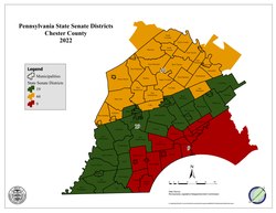
As of January 5, 2021[update]:
| District | Senator | Party |
|---|---|---|
| 9 | John Kane | Democratic |
| 19 | Carolyn Comitta | Democratic |
| 26 | Tim Kearney | Democratic |
| 44 | Katie Muth | Democratic |
Education
Colleges and universities

- Cheyney University of Pennsylvania (partially in Delaware County)
- Delaware County Community College (locations in Exton, Downingtown, Phoenixville and West Grove)
- Immaculata University
- Lincoln University
- Penn State Great Valley
- University of Valley Forge
- West Chester University of Pennsylvania
Public school districts

- Avon Grove School District
- Coatesville Area School District
- Downingtown Area School District
- Great Valley School District
- Kennett Consolidated School District
- Octorara Area School District
- Owen J. Roberts School District
- Oxford Area School District
- Phoenixville Area School District
- Spring-Ford Area School District
- Tredyffrin-Easttown School District
- Twin Valley School District
- Unionville-Chadds Ford School District
- West Chester Area School District
Charter schools
- Achievement House Charter School grades 9-12, Exton
- Avon Grove Charter School grades K-12, West Grove
- Chester County Family Academy Charter School grades K-2, West Chester
- Collegium Charter School grades K-12, Exton
- Pennsylvania Leadership Charter School K-12, West Chester
- Renaissance Academy Charter School grades K-12, Phoenixville
- Sankofa Academy Charter School grades 5–8, West Chester
- 21st Century Cyber Charter School grades 6-12. Downingtown.
Independent schoolsedit
- Bishop Shanahan High School (Archdiocese of Philadelphia)
- Center for Arts and Technology (Administered by Chester County Intermediate Unit)[27]
- Church Farm School (now called CFS the School at Church Farm)
- Delaware Valley Friends School[28]
- Devon Preparatory School
- Fairville Friends School[29] (Chadds Ford, Pennsylvania)
- Goshen Friends School[30] (West Chester, Pennsylvania)
- Kimberton Waldorf School[31] (Kimberton, Pennsylvania)
- London Grove Friends Kindergarten (Kennett Square, Pennsylvania)
- Malvern Preparatory School
- The Concept School - 6th through 12th Grade[32]
- Upattinas School and Resource Center (Glenmoore, Pennsylvania)
- Upland Country Day School (UCDS) - Pre-K through 9th Grade[33]
- Villa Maria Academy (Malvern, Pennsylvania)
- Villa Maria Academy Lower School (Immaculata, Pennsylvania)
- West-Mont Christian Academy[34]
- West Chester Friends School[35]
- West Fallowfield Christian School
- Westtown School
- Windsor Christian Academy - K through 6th Grade[36]
- Windsor Christian Preschool[37]
- Regina Luminis Academy[38]
Librariesedit
The Chester County Library System in southeastern Pennsylvania was organized in 1965. It is a federated system composed of a District Center Library in Exton and sixteen member libraries. The system provides materials and information for life, work and pleasure.
Communitiesedit

Under Pennsylvania law, there are four types of incorporated municipalities: cities, boroughs, townships, and, in at most two cases, towns. The post office uses community names and boundaries that usually do not correspond to the townships, and usually only have the same names as the municipalities for the cities and boroughs. The names used by the post office are generally used by residents to describe where they live. The following cities, boroughs and townships are located in Chester County:
Cityedit
Boroughsedit
Townshipsedit
- Birmingham
- Caln
- Charlestown
- East Bradford
- East Brandywine
- East Caln
- East Coventry
- East Fallowfield
- East Goshen
- East Marlborough
- East Nantmeal
- East Nottingham
- East Pikeland
- East Vincent
- East Whiteland
- Easttown
- Elk
- Franklin
- Highland
- Honey Brook
- Kennett
- London Britain
- London Grove
- Londonderry
- Lower Oxford
- New Garden Zdroj:https://en.wikipedia.org?pojem=Chester_County,_Pennsylvania
>Text je dostupný pod licencí Creative Commons Uveďte autora – Zachovejte licenci, případně za dalších podmínek. Podrobnosti naleznete na stránce Podmínky užití.
Text je dostupný za podmienok Creative
Commons Attribution/Share-Alike License 3.0 Unported; prípadne za ďalších
podmienok.
Podrobnejšie informácie nájdete na stránke Podmienky
použitia.

