A | B | C | D | E | F | G | H | CH | I | J | K | L | M | N | O | P | Q | R | S | T | U | V | W | X | Y | Z | 0 | 1 | 2 | 3 | 4 | 5 | 6 | 7 | 8 | 9
| Mount Bindo | |
|---|---|
 Mount Bindo Location in New South Wales | |
| Highest point | |
| Elevation | 1,364 m (4,475 ft)[1] |
| Coordinates | 33°40′38″S 150°00′35″E / 33.6772973°S 150.0096666°E[2] |
| Geography | |
| Location | Central Tablelands, New South Wales, Australia |
| Parent range | Great Dividing Range |
| Topo map | Hampton |
| Climbing | |
| Easiest route | Drive |
Mount Bindo, a mountain on the Great Dividing Range, is located in the Central Tablelands region of New South Wales, Australia.
With an elevation of 1,364 metres (4,475 ft) above sea level,[1][2] Mount Bindo is one of the highest points on the Central Tablelands and attracts regular light snowfalls in winter. Nearby towns include the hamlet of Hampton, Jenolan Caves and the town of Oberon. As with nearby Mount Trickett and Shooters Hill, Mount Bindo is a popular destination for 'snow chasers' during the winter months.
Access to the summit
From the town of Oberon, the Duckmaloi Road heads east for 26 kilometres (16 mi) until it meets the Hampton-Jenolan Caves Rd. There is a roadside rest area here on Hampton State Forest. A dry-weather forest road, the Tea Tree Road, turns left here and heads through the pines to the junction with Bindo Boundary Road. Turn left to the summit of Mount Bindo, from where there are fine views over the Megalong Valley, taking in Oberon to the west, Lithgow to the north, Blackheath and the Hydro-Majestic Hotel at Medlow Bath to the east and two towers to the south.[3]
Gallery
-
 The summit of Mount Bindo.
 -
 Trig point at the summit of Mount Bindo.
 -
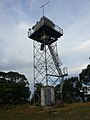 Fire Tower on the summit of Mt. Bindo.
 -
 Trig point and structures at the summit of Mt. Bindo.
 -
 Track approaching the summit of Mount Bindo.


See also
References
- ^ a b "Map of Mount Bindo, NSW". Bonzle Digital Atlas of Australia. Retrieved 27 May 2015.
- ^ a b "Mount Bindo". Geographical Names Register (GNR) of NSW. Geographical Names Board of New South Wales. six maps topo map 'Hampton'
- ^ "Oberon". Sydney Morning Herald. 10 April 2008. Retrieved 28 May 2015.
External links
- Relief maps of the area - Provided by NSW Central Ranges Weather - see link below.
- NSW Central Ranges Weather - Local site with weather information and maps etc. for the Oberon Plateau area.
- Blackheath Weather - Another site with snow and general weather information for the area.
This Central West geography article is a stub. You can help Wikipedia by expanding it. |
>Text je dostupný pod licencí Creative Commons Uveďte autora – Zachovejte licenci, případně za dalších podmínek. Podrobnosti naleznete na stránce Podmínky užití.
Text je dostupný za podmienok Creative
Commons Attribution/Share-Alike License 3.0 Unported; prípadne za ďalších
podmienok.
Podrobnejšie informácie nájdete na stránke Podmienky
použitia.

