A | B | C | D | E | F | G | H | CH | I | J | K | L | M | N | O | P | Q | R | S | T | U | V | W | X | Y | Z | 0 | 1 | 2 | 3 | 4 | 5 | 6 | 7 | 8 | 9
Northern England
North of England / the North | |
|---|---|
 The three current Northern England statistical regions combined shown within England. Other definitions of the North vary and have changed over time. | |
| Sovereign state | |
| Constituent country | |
| Regions | North East England • North West England • Yorkshire & The Humber |
| Counties |
|
| Devolved regions | |
| 10 largest settlements in order of population | |
| Area | |
| • Total | 37,331 km2 (14,414 sq mi) |
| Population (2011 census)[1] | |
| • Total | 14,933,000 |
| • Density | 400/km2 (1,000/sq mi) |
| • Urban | 12,782,940 |
| • Rural | 2,150,060 |
| Demonym | Northerner |
| Time zone | GMT (UTC) |
| • Summer (DST) | UTC+1 (BST) |
Northern England, or the North of England, is the northern area of England. It partly corresponds to the former borders of Anglian Northumbria, the Anglo-Scandinavian Kingdom of Jorvik and the Brythonic Celtic Hen Ogledd kingdoms.
The North is a grouping of three statistical regions: the North East, the North West, and Yorkshire and the Humber. These had a combined population of 14.9 million at the 2011 census, an area of 37,331 km2 (14,414 square miles) and 17 cities.
Northern England is culturally and economically distinct from both the Midlands and Southern England. The area's northern boundary is the border with Scotland, its western the Irish Sea and there may be a short border with Wales, and its eastern the North Sea. Its southern border is often debated, and there has been controversy in defining what geographies or cultures precisely constitute the 'North of England' — if, indeed, it exists as a coherent entity at all.
Many Industrial Revolution innovations began in Northern England, and its cities were the crucibles of many of the political changes that accompanied this social upheaval, from trade unionism to Manchester Liberalism. In the late 19th and early 20th centuries, the economy of the North was dominated by heavy industry. Centuries of immigration, invasion, and labour have shaped Northern England's culture, and it has retained countless distinctive accents and dialects, music, arts, and cuisine. Industrial decline in the second half of the 20th century damaged the North, leading to greater deprivation than in the South. Although urban renewal projects and the transition to a service economy have resulted in strong economic growth in parts of the North, the North–South divide remains in both the economy and culture of England.
Definitions
For government and statistical purposes, Northern England is defined as the area covered by the three northernmost statistical regions of England: North East England, North West England and Yorkshire and the Humber.[2] This area consists of the ceremonial counties of Cheshire, Cumbria, County Durham, East Riding of Yorkshire, Greater Manchester, Lancashire, Merseyside, Northumberland, North Yorkshire, South Yorkshire, Tyne and Wear and West Yorkshire, plus the unitary authority areas of North Lincolnshire and North East Lincolnshire within the ceremonial county Lincolnshire.

Other definitions use historic county boundaries, in which case the North is generally taken to comprise Cumberland, Northumberland, Westmorland, County Durham, Lancashire and Yorkshire, often supplemented by Cheshire.[3] The boundary is sometimes drawn without reference to human borders, using geographic features such as the River Mersey (the line between the Humber and Mersey estuaries being a common boundary) and River Trent.[4] The Isle of Man is occasionally included in broad geographical definitions of "the North" (for example, by the Survey of English Dialects, VisitBritain and BBC North West), although it is politically and culturally distinct from England.[3]
Some areas of Derbyshire, Lincolnshire, Nottinghamshire and Staffordshire have northern characteristics and include satellites of northern cities.[4] Towns in the High Peak borough of Derbyshire are included in the Greater Manchester Built-Up Area, as villages and hamlets there such as Tintwistle, Crowden and Woodhead were formerly in Cheshire before local government boundary changes in 1974,[5] due to their close proximity to the city of Manchester, and before this the borough was considered to be part of the Greater Manchester Statutory City Region. More recently, the Chesterfield, North East Derbyshire, Bolsover, and Derbyshire Dales districts have joined with districts of South Yorkshire to form the Sheffield City Region, along with the Bassetlaw District of Nottinghamshire, although for all other purposes these districts still remain in their respective East Midlands counties. Some parts of northern Derbyshire (including High Peak), Shropshire and Staffordshire are served by BBC North West. Some areas of Derbyshire and Nottinghamshire are served by BBC Yorkshire (formerly BBC North), whilst eastern Yorkshire shares its BBC region with Lincolnshire and small parts of Nottinghamshire and north west Norfolk.[6] The historic part of Lincolnshire known as Lindsey (in essence the northern half of the county) is considered by many to be northern, or at least a larger part of Lincolnshire than merely the north and northeast Lincolnshire districts. The geographer Danny Dorling includes most of the West Midlands and part of the East Midlands in his definition of the North, claiming that "ideas of a midlands region add more confusion than light".[7]
Conversely, more restrictive definitions of Northern England also exist. Some are based on the extent of the historical Northumbria, which excludes Cheshire and northern Lincolnshire, though the latter formed the Kingdom of Lindsey, which was periodically under Northumbrian rule.[8] The Redcliffe-Maud Report (1969) proposed that southern Cheshire be grouped with north Staffordshire as part of a West Midlands province as opposed to a North West England one.[9] Occasionally, "Northern England" may be used to describe England's northernmost reaches only, broadly the North East and Cumbria, excluding the entirety, or at least the majority, of Lancashire and Yorkshire. Some settlements, including Sheffield, located in the far south of what would typically be defined as "the North", have been referred to as being in the "North Midlands" as opposed to "the North".[10]
Personal definitions of the North vary greatly. When asked to draw a dividing line between North and South, Southerners tend to draw this line further south than Northerners do.[8] From the Southern perspective, Northern England is sometimes defined jokingly as the area north of the Watford Gap between Northampton and Leicester[a] – a definition which would include much of the Midlands.[8][12] Various cities and towns have been described as or promoted themselves as the "gateway to the North", including Crewe,[13] Stoke-on-Trent,[14] and Sheffield.[15] For some in the northernmost reaches of England, the North starts somewhere in North Yorkshire around the River Tees – the Yorkshire poet Simon Armitage suggests Thirsk, Northallerton or Richmond – and does not include cities like Manchester and Leeds, nor the majority of Yorkshire.[16][17] Northern England is not a homogeneous unit,[18] and some have entirely rejected the idea that the North exists as a coherent entity, claiming that considerable cultural differences across the area overwhelm any similarities.[19][20]
Geography

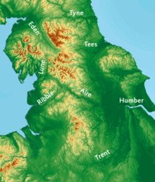
The Pennines, an upland range sometimes referred to as "the backbone of England" run through most of the area defined as northern England, which stretches from the Tyne Gap to the Peak District. Other uplands in the North include the Lake District with England's highest mountains, the Cheviot Hills adjoining the border with Scotland, and the North York Moors near the North Sea coastline.[21]
The geography of the North has been heavily shaped by the ice sheets of the Pleistocene era, which often reached as far south as the Midlands. Glaciers carved deep, craggy valleys in the central uplands, and, when they melted, deposited large quantities of fluvio-glacial material in lowland areas like the Cheshire and Solway Plains.[22] On the eastern side of the Pennines, a former glacial lake forms the Humberhead Levels: a large area of fenland which drains into the Humber and which is very fertile and productive farmland.[22]

Much of the mountainous upland remains undeveloped, and of the ten national parks in England, five – the Peak District, the Lake District, the North York Moors, the Yorkshire Dales, and Northumberland National Park – are located partly or entirely in the North.[b] [23][24] The Lake District includes England's highest peak, Scafell Pike, which rises to 978 m (3,209 ft), its largest lake, Windermere, and its deepest lake, Wastwater.[25] Northern England is one of the most treeless areas in Europe, and to combat this the government plans to plant over 50 million trees in a new Northern Forest.[26]
Urban
| Rank | Counties | Pop. | Rank | Counties | Pop. | ||||
|---|---|---|---|---|---|---|---|---|---|
 Leeds  Liverpool |
1 | Leeds | West Yorkshire | 536,280 | 11 | Blackpool | Lancashire | 149,070 |  Sheffield  Manchester |
| 2 | Zdroj:https://en.wikipedia.org?pojem=North_England|||||||||


