A | B | C | D | E | F | G | H | CH | I | J | K | L | M | N | O | P | Q | R | S | T | U | V | W | X | Y | Z | 0 | 1 | 2 | 3 | 4 | 5 | 6 | 7 | 8 | 9
Kryvyi Rih
Кривий Ріг | |
|---|---|
From upper left: Historical centre, Kryvyi Rih-Main railway station, ArcelorMittal Kryvyi Rih, Quarter 95, the boat station on the Saksahan, a landscape of the Inhulets from Eagle's Nest | |
| Motto: Life-long city[citation needed] | |
| Anthem: Anthem of Kryvyi Rih | |
 Kryvyi Rih Location of Kryvyi Rih in Ukraine  Kryvyi Rih Location of Kryvyi Rih in Europe | |
| Coordinates: 47°55′N 33°23′E / 47.91°N 33.39°E | |
| Country | Ukraine |
| Oblast | Dnipropetrovsk Oblast |
| Raion | Kryvyi Rih Raion |
| Hromada | Kryvyi Rih urban hromada
|
| Historic Governorate | Zaporizhzhian Sich (1734 – 1774) Azov Governorate (1775 – 1781) |
| Founded | 1775 (249 years ago) |
| Town charter | 1860 |
| City status | 1919 |
| Administrative HQ | Kryvyi Rih City Hall, Ploshcha (Square) Molodizhna |
| Raions | List of 7 districts |
| Government | |
| • Type | City council, regional |
| • Mayor | City council secretary Yuri Vilkul (Mayor Konstantyn Pavlov died on 15 August 2021, since then his powers are temporarily exercised by the city council secretary)[1] |
| • Governing body | Kryvyi Rih City Council |
| • Head of military administration | Oleksandr Vilkul[2] |
| Area | |
| • City | 431 km2 (166 sq mi) |
| • Rank | 2nd, UA |
| Elevation | 84 m (276 ft) |
| Population (2022) | |
| • City | 603,904 |
| • Rank | 8th, UA |
| • Density | 1,400/km2 (3,600/sq mi) |
| • Metro | 1,170,953 |
| (2019) | |
| Time zone | UTC+2 (EET) |
| • Summer (DST) | UTC+3 (EEST) |
| Postal code | 50000-50479 |
| Area code | +380 56(4) |
| Website | krmisto |
.jpg)
.jpg)


Kryvyi Rih (/ˈkrɪviː ˈriː/; Ukrainian: Кривий Ріг, IPA: [krɪˌwɪj ˈr⁽ʲ⁾iɦ] ), also known as Krivoy Rog (Russian: Кривой Рог),[4] is a city in central Ukraine. It hosts the administration of Kryvyi Rih Raion and its subordinate Kryvyi Rih urban hromada in Dnipropetrovsk Oblast.[5] The city is part of the Kryvyi Rih Metropolitan Region. Its population is estimated at 603,904 (2022 estimate),[6] making it the seventh-most populous city in Ukraine and the second largest by area. Kryvyi Rih is claimed to be the longest city in Europe.[7][8]
Located at the confluence of the Saksahan and Inhulets rivers, Kryvyi Rih was founded as a military staging post in 1775. Urban-industrial growth followed Belgian, French and British investment in the exploitation of the area's rich iron-ore deposits, generally called Kryvbas, in the 1880s. Kryvyi Rih gained city status after the October Revolution in 1919.
Stalin-era industrialisation built Kryvorizhstal in 1934, the largest integrated metallurgical works in the Soviet Union. After a brutal German occupation in World War II, Kryvyi Rih experienced renewed growth through to the 1970s. The economic dislocation associated with the break-up of the Soviet Union contributed to high unemployment and a large-scale exodus from the city in the 1990s. The privatization of Kryvorizhstal in 2005 was followed by increased foreign and private investment which helped finance urban regeneration. Beginning in 2017, there were major labour protests and strikes.
In the February 2022 invasion of Ukraine, forces of the Russian Federation approached the city's outskirts from Russian-occupied Crimea. In March 2022, their advance stalled some 50 km to the south. The city has since been a target of frequent missile strikes.
Etymology
Kryvyi Rih, which in Ukrainian literally means 'crooked horn' or 'curved cape', was the name originally given in the 18th century to the general area of the present city by Zaporozhian Cossacks. According to local legend, the first village in the area was founded by a "crooked" (Ukrainian slang for 'one-eyed') Cossack named Rih (literally, 'horn'). The name likely derives from the shape of the landmass formed by the confluence of the river Saksahan with the Inhulets.[9]
History
Early history
In 1734 the Cossack Zaporizhian Sich (or Host) incorporated the area within the Inhul Palanka division of their de-facto republic. A list of villages and winter camps (zymivnyki) from that time mentions Kryvyi Rih. In 1770, Kryvyi Rih was again recorded as the camp of the Zaporizhian Sich.[10][11]
In May 1775, after the end of the Russian-Turkish War, Russian authorities established Kryvyi Rih as a staging post, in the tradition of the Mongol yam, on the roads to the Russian garrisons of Kremenchuk, Kinburn foreland and Ochakov.[12] In August 1775, on the direct order of Catherine the Great, the Sich was forcibly dissolved. The cossack lands were annexed to the Russian province of Novorossiya and distributed among the Russian and Ukrainian gentry.[13]
The early 19th century saw the construction of the first stone houses (1828), and three water mills.[14] In 1860, the village was designated a township.[15]
Industrial growth
Alexander Pol discovered and initiated iron ore investigation and production in this area. He is credited with discovering the Kryvbas.[16][17] This stimulated the formation of a mining district.[18] In 1884, Alexander III started the Catherine Railway, first to Dnipro and then 505 km to the coal-mining region of Donbas.[19][20]
In 1880, with 5 million francs of capital, Pol founded the "French Society of Kryvyi Rih Ores". In 1882 16.4 thousand tons of ore were extracted from surface mines on the outskirts of town by 150 workers. The first underground mine of the basin began operations in 1886.[21] In 1892, the Hdantsivka ironworks was started. Ore began to be processed locally, spawning new metallurgical enterprises spurred by substantial western, and in particular Belgian,[22] investment. At the same time Kryvyi Rih ore began to feed the German metallurgical industry in Silesia. In 1902, the Catherine Railroad linked Kryvyi Rih to the coal mines of the Donbas.[20]
-
 Kryvyi Rih's synagogue, 19th century
 -
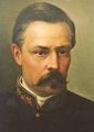 Alexander Pol studied iron ore in detail and proved its commercial value
 -
 An ore quarry in 1899
 -
 Joltaїa Rieka Iron Mining Company share, 1899
 -
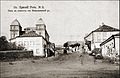
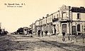 Poshtova Street about 1900
 -
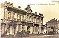 Kryvyi Rih Mutual Credit Society
 -
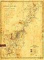 A regional map in 1914
 -
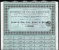 Minerais de Fer de Krivoї Rog share


At the end of the 19th century the tallest building was the Central Synagogue, built by a thriving Jewish community of artisans, merchants and traders.[15] In 1905, the community was subject to pogroms, in which the authorities were complicit. Many Jewish people left the area, emigrating to Germany, Austria-Hungary and the United States.[23]
The surrounding mines attracted prospectors looking to turn a quick profit.[24] The supply of mined ore soon exceeded demand. Many mines had to cut employment or temporarily suspend operations. Workers, many drawn from the Russian-speaking north (from Great Russia),[25] laboured in harsh conditions with no security. Work in the mines induced lung cancer, tuberculosis and asthma.[26] In protest, workers began to develop ideas about socialism and democracy. Labour unrest resulted in several terrorist attacks and in widespread strikes.[27]
The First World War interrupted access to the export markets, and many workers were drafted into the military. A council of soviet of Soldiers and Worker's Deputies was formed in 1917. January 1918 saw the first attempt by the Bolsheviks to establish the authority in the town of the new Soviet government in Moscow.[28][29]
Russian Civil War
In the civil war that followed the Bolshevik Revolution of October 1917, Kryvyi Rih changed hands several times. In February 1918, the Bolsheviks proclaimed the Donetsk-Krivoy Rog Soviet Republic, but then in March conceded the territory under the terms of the Treaty of Brest-Litovsk to the German-controlled Ukrainian State.[30] After the Germans and their Austro-Hungarian allies withdrew in November 1918, the town was successively occupied by the nationalists of the Ukrainian People's Republic, the counter-revolutionary Volunteer Army of General Denikin (the "Whites"),[28] the anarchist Revolutionary Insurgent Army of Ukraine (the Makhnovshchina)[31] and, from 17 January 1920, by the Bolshevik Red Army.[32] In 1922 the region was incorporated into the Ukrainian SSR, a constituent republic of the Soviet Union.
Soviet era
Industrialisation and collectivisation
The town, with a population of 22,571, was now designated a city. Mine operations were revived, and in 1924 a 55.3 km (34.4 mi) water-supply system was laid underground. In the summer of 1927, 10,000 people began to work on the Dnieprostroi, a huge dam on the Dnieper River in Zaporizhzhia, whose hydro-electric power drove Kryvyi Rih's industrialisation.[33] The first Mining Institute opened in 1929. The Medical and Pedagogical Institutes were founded.[34]
In line with Stalin's plans for break-neck industrialisation, in 1931 the foundation of the Kryvyi Rih Metallurgical Plant, the future Kryvorizhstal, was laid.[35] The first blast furnace of the metallurgical works produced steel three years later. The city grew rapidly.[36] In the surrounding countryside, industrialisation was accompanied by the collectivisation of agriculture. The dispossession of the peasants and the confiscation of their harvests induced the Holodomor or Great Famine of 1932–33.[37]
By 1941, at over 200,000, the population of the industrial city had increased almost tenfold.[38]
Nazi occupation
During World War II, Kryvyi Rih was occupied by the German Army from 15 August 1941 to 22 February 1944. It was administered for most of that period as part of the Reichskommissariat Ukraine. In advance of the Germans, industrial plant and machine operators were evacuated to Nizhny Tagil in the Urals.[32] An initial toleration of Ukrainian cultural activity and propaganda by the pro-German Organization of Ukrainian Nationalists in the town ended in January and February 1942 with the arrest and execution of the leading Ukrainian activists.[39]
In 1939, 12,745 Jews had lived in Krivoy Rog, comprising about 6 per cent of the total population. Those who did not leave the city during the organized evacuation were systematically concentrated and murdered by the Nazi occupiers. The first mass killing of two to three hundred by an Einsatzkommando occurred at the end of August 1941 at a brick works. On 14–15 October a combination of SS, German police and Ukrainian auxiliaries murdered 7,000 more at an iron ore mine. Children were thrown into the pits alive.[40]
Hitler had repeatedly stressed the crucial importance of this area: "The Nikopol manganese is of such importance, it cannot be expressed in words. Loss of Nikopol (on the Dnieper River, today's southwest of Zaporizhzhia) would mean the end of war."[41] The German bridgehead on the left bank of the Dnieper gave the German command a base in order to restore the land connection with their forces locked in the Crimea.[42] During the first half of January 1944,[43] Soviet troops made repeated attempts to eliminate the Nikopol-Krivoy Rog enemy group. The Nikopol–Krivoy Rog Offensive did not succeed in breaking into the city until the end of February. Although the greater part of city was destroyed, a special 37th Red Army detachment prevented the German demolition of the power stations in the city and the Saksahan dams.[44]
-
 AEG power station built in 1930
 -
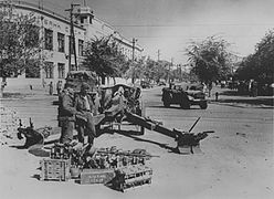 Wehrmacht soldiers operating 10.5 cm leFH 18. Svobody Street, 1942
 -
 Soldiers arresting people, 1942
 -
 Miners and pioneers pose in front of the Banner of Krivoi Rog. 1952.
 -
 Dimitrova Street, like many in the city center, is lined with dozens of Stalinist buildings
 -
 City Hall was built in the year of the city's 200th jubilee.
 -
 Nativity of the Theotokos Church, 1886, restored in the 2000s[45]


Post-war
After the war, people lived among the ruins while rebuilding the housing stock. The housing shortage was met by innovative technological solutions, and temporary barracks and houses were quickly built.
In the late 1940s, re-construction was accompanied by Stakhanovite propaganda:[46] Pre-war iron ore production was restored by 1950.[32] In 1961 this was supplemented by new mines and by the Central and, Northern Iron Ore Enrichment Works.[47] By the end of the Soviet era, Kryvbas was producing 42% of the USSR's and 80% of Ukrainian ore.[48]
At the beginning of the 1960s, the city received a signature 185m-tall, guyed tubular steel TV mast.[49] Housing stock was replaced and expanded with several large Khrushchyovkas apartment complexes. Urban planning incorporated broad tree-lined avenues with trams lines running down their center.[50]
On June 16–18, 1963, increased food prices triggered protests in the city, estimated to involve between 1,000 and 6,000 people.[51] After an ex-serviceman who had interacted with the police was severely beaten, there was rioting. Moscow sent in troops. While the authorities admitted to 4 dead and 15 wounded, witnesses report that soldiers killed at least 7, and that over 200 people were hospitalised with injuries.[52] Fifteen hundred people received prison sentences.[32]
In 1975, the city's two-hundredth anniversary was marked by the development of the Jubilee mine and adjacent residential area, and by the construction of a new city administration building and park. In September 1976, the Krivorozh wool spinning factory was commissioned.[32]
In last years of the Soviet Union, and following a sharp reduction in spending on cultural, sports and youth service, the city witnessed neighbourhood-based gang violence—the so-called "war of Runners".[53] The era of Perestrioka was also marked by the emergence of independent trade unions, and of new civic and political organisations.[54]
The former Krivoi Rog Air Base is located nearby.
In independent Ukraine
Redevelopment and politics
In a national referendum on 1 December 1991, Ukrainian independence was approved by 90% of the votes cast in Kryvyi Rih's Dnipropetrovsk Oblast.[55] The first 25 years of independence was a period of economic dislocation and adjustment. The population of the city decreased by almost 100,000, from a peak of 780,000 in the late 1980s.[56][38]
Assisted by Metinvest, investment followed the 2005 privatization of Kryvorizhstal.[57] There was extensive redevelopment including new shopping and entertainment centers.[58] In July 2020 as part of the administrative reform of Ukraine, Kryvyi Rih Municipality and the Kryvyi Rih Raion came under a common city authority.[59][60] The city remains the second most important in the Dnipropetrovsk region after Dnipro. Krivyi Rih has two independent universities, and several institutes and technical schools.[32]
Until the events of Euromaidan in 2014 and their aftermath, in local and national elections Kryvyi Rih favored Russian-friendly candidates belonging first, in the 1990s, to the Communist Party of Ukraine and then, in the new century, the Party of Regions. In 2010 the city elected Party of Regions Yuriy Vilkul mayor, and helped Viktor Yanukovych to victory in the presidential election. After the Euromaidan events, which were accompanied by demonstrations and clashes in the city centre,[61] support began to ebb from the Party of Regions. Petro Poroshenko, who insisted that Russian separatists in the Donbas "don't represent anybody",[62] was supported in the presidential election of 2014. Vilkul was re-elected mayor in 2015, but amidst large-scale protests alleging electoral fraud.[63][64]
In the 2019 Ukrainian presidential election the city supported its native son Volodymyr Zelenskyy,[65] who defeated Poroshenko in the second round in April.[66][67][68] In the July 2019 elections for the Ukrainian Rada, candidates for Zelenskyy's Servant of the People Party won the city's three parliamentary seats. However, in December 2020, the Servant of the People candidate for mayor, Dmytr Shevchuk, lost to Kostantin Pavlov of the pro-Russian Opposition Platform — For Life.[69]
On 15 August 2021, Pavlov was found dead in the entrance to his home, a gun lying next to his body.[70] In September, reporting on an investigation that included a search of the home of the former, and now acting, mayor, Yyriy Vilkul,[71] the Minister of Internal Affairs Denys Monastyrsky suggested that Pavlov may have committed suicide against the backdrop of a large-scale audit of the city's budget.[72]
Labour protests
Beginning in 2017, Kryvyi Rih had major labour unrest. In May 2017, coordinated protest actions began at the city's main plants, Kryvyi Rih Iron Ore Plant, Evraz-Sukha Balka and AMKR. Employees stopped work, held public meetings and occupied administration offices. Conscious that they were receiving one of the lowest wages across the global industry, the metalworkers raised the demand for a monthly wage of US$1,000/Euros. The conflict stopped after an agreement was reached to gradually raise wages, on average by 50%. In 2018, protest erupted again triggered by the fatal result of underinvestment in plant and safety. On the night of 3–4 March 2018, the roof collapsed at AMKR's converter shop, killing a 25-year-old worker.[73]
In May, the ArcelorMittal steel plant ground to a halt as workers refused to guide trains along the factory's self-enclosed supply chain until they received monthly pay of 1,000 euros. Management brought in employees from state-owned railway company Ukrzaliznytsia to run the factory, breaking the strike but leaving the central dispute in place. An underlying problem, according to ArcelorMittal's chief procurement officer, is a labour shortage. Skilled workers are emigrating to Poland, Czechia, and to other countries. But the plant's upper management sees costs associated with the higher salaries that might retain workers as an unacceptable threat to an ambitious, multibillion-dollar factory modernization project.[74]
Kryvorizhstal, Ukraine's largest integrated steel company, had been privatised in 2005 in publicly televised auction. This was after the incoming government of President Viktor Yushchenko cancelled a 2004 auction that had seen the company sold at a much lower price, to a consortium that included the son-in-law of ex-President Leonid Kuchma. The Indian-owned international steel conglomerate Mittal Steel proved successful with a bid of $4.8 billion, equivalent to a fifth of Ukraine's national budget.[75] In 2006, Mittal took over its international rival, Arcelor, to form ArcelorMittal headquartered in Luxembourg City.[76] Over the next five years, the company said it invested more than $5 billion in its Kryvyi Rih operations.[77]
On 15 October 2020, in an action that began with 393 miners occupying mine-shafts,[78] 18 iron-ore miners came to the surface after spending a total of 43 days underground to protest pay and conditions. The mine administration had introduced piecework wages for most jobs underground, linking people's daily income to the amount of ore mined. In response to this, and to above-ground worker blockades, plant management made concessions on wages, benefits and health and safety.[79][77]
2022 Russian invasion
On the first day of the invasion of Ukraine by Russia, 24 February 2022, there were air strikes against military targets in the city, causing evacuations of residents in the district of Makulan.[80]
On 27 February, city mayor Oleksandr Vilkul was appointed the head of the military administration of Kryvyi Rih.[2] According to Vilkul, the day previously — the second day the war — the Russian military had attempted an air assault. An Ilyushin Il 76 transport had approached an abandoned Soviet-era air base just east of the city. Carrying more than 100 paratroopers with orders to capture the airfield as an “air bridge”, it was forced to abort its mission, 300 metres from landing. As soon as the city had been hit with missiles, local defenders had blocked the runway with mechanical equipment.[65][22] On the same day, Vilkul said that he had received a phone call from a former colleague who invited him to "sign an agreement of friendship, cooperation and defense with Russia"; he said that he "responded with profanity."[81]
On the third day of the war, 27 February, the Russian forces, according to Vilkul, sent a column of 300 military vehicles from their advancing position to the south, and that after ten days of intense fighting they were turned back. As an industrial center that accounted for fully 10% of Ukraine's GDP, Vilkul was convinced that Kryvyi Rih was a prime target for Russian forces.[82]
In the third week of the war, Russian troops broadened their offensive across Ukraine and were again advancing toward Kryvyi Rih from the south.[83] On 10 March, two rockets struck the Kryvyi Rih International Airport in Lozovatka.[84] On 12 March, Metinvest shuttered an open pit iron ore mine in the city, and sent the huge trucks used at the mine to block key roads to slow the Russian advance.[85] In its 15 March briefing, the Ukrainian Ministry of Defence stated that the movement by "occupation troops" toward Kryvyi Rih had been stopped.[86]
According to Russian sources, the invaders faced extensive improvised fortifications and minefields.[87] On 29 March 2022, Vilkul said that the line of contact was no longer on the border with Dnipropetrovsk region, but 40-60 kilometers south in the Kherson Oblast.[88] He was confident that running 120 km north to south, the longest city in Europe could not be surrounded.[22]
.jpg)
On 30 March, ArcelorMittal which at the beginning of the month had idled its steelmaking operations in Kryvyi Rih citing concern for the safety and security of its 26,000 workers and for its assets,[89][90] announced that it was preparing to restart production.[91] It 2023, it operated at 25% pre-war capacity. In 2024, the company plans to increase capacity utilization from to 50%.[92]
At the end of May, responding to Russian rocket and missile strikes, Ukrainian forces made limited counterattacks south of Kryvyi Rih.[93] The southern Inhulets and Radushne districts remain exposed to Russian shelling with civilian losses.[94] At dawn on 25 August, Kryvyi Rih was hit by cluster munitions.[95]
On 14 September 2022, the city faced rising water levels in the Inhulets River, and water shortages, as the Russian forces fired eight cruise missiles at local infrastructure.[96] The strike against President Zelenskyy's home town—an attempt, he suggested, to flood the city—came after his visit to towns in the Kharkiv region regained in Ukraine's first major counteroffensive.[97]
Government

|
The city of Kryvyi Rih is governed by the Kryvyi Rih Municipality. It is a city community that is designated as a separate district within its oblast.
Administratively, the city is divided into districts (raions). There are 7 districts: Metalurhiinyi, Tsentralno-Miskyi, Ternivskyi, Saksahanskyi, Inhuletskyi, Pokrovskyi and Dovhyntsivskyi. Small townships, Avanhard, Horniatske, Ternuvatyi Kut, Kolomiitseve and Novoivanivka were added to the city.[98]
In 1775, the Inhulets Povit (territory) of Novorossiysk Governorate was established on lands of the Inhulets palanca, after the abolition of the Zaporozhian Sich. In 1775/1776 it was part of Kherson Governorate. In 1783, the povit centre became Kryvyi Rih, and it was renamed "Kryvyi Rih Povit". In 1860, Kryvyi Rih received the status of township within the Kherson Governorate. In 1919, the township was granted city status in Yekaterinoslav Governorate and, later, Dnipropetrovsk Oblast. As a result of the administrative reform in 1923, Kryvyi Rih povit converted to Kryvyi Rih county. In 1930, it became an independent administrative unit of Ukraine.[99][100]
Kryvyi Rih has four single-mandate parliamentary constituencies entirely within the city, through which members of parliament (MPs) are elected to represent the city in Ukraine's national parliament. At the 2014 Ukrainian parliamentary election, they were won by Petro Poroshenko Bloc and independent candidates with representation being from Yuri Pavlov, Andriy Halchenko, Konstantin Usov respectively.[101]
In multimember districts, the city voted for the Opposition Bloc, a union of all political forces that did not endorse Euromaidan. At the 2019 Ukrainian parliamentary election, three local MPs were representing Servant of the People, the party of Ukrainian President and Kryvyi Rih native Volodymyr Zelenskyy, and one independent candidate, Dmytro Shpenov.[66][67][68]
Culture

Kryvyi Rih has a thriving theatre, circus and dance scene, and is home to a number of large performance venues. There are also the Doll Theatre and Movement Theatre. The first theater was the Coliseum, built in 1908. The New Theatre of Vyzenberh and Hrushevskyy followed in 1911, at the corner of Lenina and Kalynychenko streets. Kryvbas Theatre began its activities in 1931, and three years later was incorporated with the Shevchenko Theater.
Kryvyi Rih is noted as the birthplace Eugenie Gershoy. She emigrated to the United States with her family in 1903, and there became an American sculptor and watercolorist. Gershoy's work is in the collections of the Whitney Museum of American Art, the Metropolitan Museum of Art, and the Smithsonian American Art Museum. Her papers are held at Syracuse University.[103] Indie band Brunettes Shoot Blondes, folk musician Eduard Drach, actress Helena Makowska, and dancer Vladimir Malakhov originated from the city.
The first film screenings were conducted in the city in the early 1920s. In 1934 Lenin Cinema was built. Today there are three movie theaters: Olympus, Odessa and Multiplex.[104] The Kryvyi Rih Circus features large-scale exhibition space where fairs are held.[105] A remnant of Soviet heritage are Palaces of Culture, located in every district of the city.
The local historical museum celebrates Cossack history, the industrial heritage of the area and its role in the Soviet State. The municipally owned Art Gallery houses a collection of local paintings.[106]
The nightlife of the city has expanded significantly since the 2000s. Big clubs such as Hollywood[107] and Sky have attracted touring DJs and pop and rap performers. Another major scene of the city is the Palace of Youth and Students of the Kryvyi Rih National University (KNU).[108] The most popular fast-food, McDonald's, is located at Kvartal 95 neighborhood.
Ukrainian cuisine is found adjacent to a range of Jewish and popular American foods: bagels, cheesecake, hot dogs, shawarma and pizza. Japanese cuisine and other Asian restaurants, hookahs, sandwich joints, trattorias and coffeehouses have become ubiquitous. Other well-known places include City Pub and Prado Cafe. The city is home to the annual electronic music Turbofly festival.[109] Rock music, a tradition in Ukraine, is an important part of the city's life and is hosted in few small pubs.
Landmarks
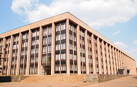
Kryvyi Rih's buildings display a variety of architectural styles, ranging from eclecticism to contemporary architecture. The widespread use of red brick and block apartments characterize the city. Much of the architecture in the city was built during its prosperous days as a center for the ore trade. Just outside the immediate city center is a large number of former factories. Some have been totally destroyed. Others are in desperate need of restoration.
Stalinist architecture was the predominant style of postwar apartments, of 5 to 7 stories. City Hall is the best example of The decree On liquidation of excesses.[110] Khrushchyovka are a type of low-cost, concrete-paneled or brick three- to five-storied apartment building which was developed in the USSR during the early 1960s. They are named after Nikita Khrushchev, then premier of the Soviet government. Dozens of these aging buildings around the city are now past their design lifetime.
Kryvyi Rih has six microdistricts.
The city has many Christian churches, the most notable being the Savior Transfiguration Cathedral of the Ukrainian Orthodox church in union with the Russian Orthodox Church. It is the base of the Kryvyi Rih Eparchy, which was established in July 1996.[111] A Roman Catholic chapel located in the old town, Pokrova church, Mykhailivska church and Christmas church were destroyed in the 1930s during the Great Purge, never to be used as a church again.[112] Beside the Russian jurisdiction, in 2009 to 2011 there existed parallel eparchy of the Orthodox Church of Ukraine (as the Ukrainian Orthodox Church – Kyivan Patriarchate). Domination of the pro-Russian political party Party of Regions in Kryvyi Rih expelled that organization.
In 2010, the Jewish community built a new, large synagogue.[113][114]
Large parks hold many of Kryvyi Rih's public monuments. There are numerous socialist realism-style monuments installed in the Soviet years to honor Cossacks, Olexander Paul, Taras Shevchenko (2), Bohdan Khmelnytsky (3, since 1954), Vasili Marguelov, Alexander Pushkin, Fyodor Sergeyev, Mikhail Lermontov, and Maxim Gorky. The few Lenin monuments were destroyed during euromaidan events in 2014.[115] Dozens of cenotaphs and memorials to Second World War soldiers were erected. A Sukhoi Su-15 is on display near the Aviator Club, a Yakovlev Yak-40 at the National Aviation University, Vyzvolennia Square holds a IS3 tank, and a Russian locomotive class Ye is placed near the Railway station.
-
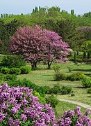 Kryvyi Rih Botanical Gardens of NAS
 -
 Shevchenko Theatre
 -
 Central Art Square
 -
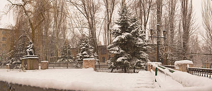 Pushkin park in snow


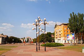
Kryvyi Rih has few[116] designated natural monuments: the old pear near Karnavatka, another pear of 1789,[117] Vizyrka landscape reserve, Northern and Southern Red Beam, Amphibolite, Arkose and Skelevatski Outputs, Mopr Rocks, Slate rocks, Sandstone rock.[118] A park named after the newspaper Pravda is very famous for its ampir boat station.[119] Kryvyi Rih Botanical Gardens of the National Academy of Sciences of Ukraine (NAS) was established in 1980.[120]
Geography


Located 316 kilometres (200 mi) south of Kyiv, the city is the biggest by size within the Central Ukraine and being situated in the right-bank portion of Dnipropetrovsk Oblast. In addition, the city is located right on the conditional border where Dnieper Upland transitions to Black Sea Lowland. The Dnieper Upland is part of the Ukrainian Crystalline Shield which in the region contains number of heavy metal deposits such as iron and uranium ores and hard rock deposits like granite. Combination of the crystalline shield with the near flowing river of Dnieper causes the plain-relief river looking as mountainous and running through rapids (Dnieper rapids).
Also, the city is often claimed to be the longest in Europe. It is said up to 100 km[7] or even 126 kilometres (78 mi) [8] from north to south. While the city is strikingly elongated on a map, in reality the greatest distance between two points within city limits is 66.1 km. The longer figures result from drawing a line precisely following the heavily indented city limits from north to south.[121]
The city area is not contiguous, with part of the Inhulets District being an exclave to the city proper. There isn't a continuous built up area along the full length of the city. Kryvyi Rih's shape is influenced by the ore deposits which lie parallel to it and which have been the city's mining mainstay. The city centre is on the east bank of the Inhulets River, near its confluences with its tributary river Saksahan. Both Inhulets and Saksahan change their river course in the area often bending in each direction. The confluence of the river Saksahan with the Inhulets supposedly gave the name for the city by forming a geographical crooked horn ("kryvyi rih").[122]
The city is set in the rolling steppe land surrounded by fields of sunflowers and grain. A short distance east of the city center, there is an area along a small lake where glacial boulders were deposited. As a result, this area was never cultivated and contains one of the few remaining patches of wild steppe vegetation in the area. The city's environmental and construction safety is a growing problem due to abandoned mines and polluted ore-processing waste.
Climate
Kryvyi Rih has a dry warm hot-summer continental climate (Dfa) within to the Köppen climate classification system, like much of southern Ukraine. This tends to generate warm summers and cold winters with relatively low precipitation. Snowfalls are not common in the city, due to the urban warming effect. Districts that surround the city receive more snow and roads leading out of the city can be closed[123] due to snow.[124]


.jpg&veda=0)
.jpg&veda=0)
.jpg&veda=0)