A | B | C | D | E | F | G | H | CH | I | J | K | L | M | N | O | P | Q | R | S | T | U | V | W | X | Y | Z | 0 | 1 | 2 | 3 | 4 | 5 | 6 | 7 | 8 | 9

(Each dot is linked to the corresponding park article)
As of 2024[update], there are 124 state parks in the U.S. state of Pennsylvania.[1] The Pennsylvania Bureau of State Parks, a division of the Pennsylvania Department of Conservation and Natural Resources (DCNR), is the governing body for all these parks, and directly operates 116 of them. The remaining parks are operated in cooperation with other public and private organizations.
The first Pennsylvania state park, at Valley Forge, opened in 1893 and was given to the National Park Service (NPS) for the United States Bicentennial in 1976. There are a total of seventeen former Pennsylvania state parks: four former parks have been transferred to the NPS, four to the Pennsylvania Historical Museum Commission, two to the U.S. Army Corps of Engineers, one to both the Corps and the Pennsylvania Game Commission, five to the Pennsylvania Bureau of Forestry, and one has ceased to exist. Nine current and two former state parks have had major name changes or have been known under alternate names.
The list gives an overview of Pennsylvania state parks and a brief history of their development since the first park opened in 1893. State parks range in size from 3 acres (1.2 ha) to 21,122 acres (8,548 ha) and comprise one percent of Pennsylvania's total land area.[2] According to Dan Cupper (1993), "Pennsylvania is the thirty-third largest state, but only Alaska and California have more park land".[3][4]
Overview
There are state parks in 62 of Pennsylvania's 67 counties, which nearly reaches Pennsylvania's goal of having a state park within 25 miles (40 km) of every resident in the Commonwealth.[5] Eleven parks do not have "State Park" in their name. Three are "Conservation Areas": Boyd Big Tree Preserve, Joseph E. Ibberson, and Varden; four are "Environmental Education Centers": Jacobsburg, Jennings, Kings Gap (also a "Training Center") and Nolde Forest; White Clay Creek is a "Preserve"; Norristown is a "Farm Park"; and Big Spring is a "State Forest Picnic Area".[6]
Seven parks are undeveloped with no facilities: Allegheny Islands, Benjamin Rush, Bucktail, Erie Bluffs, Prompton, Swatara, and Varden; the last four of these are in the process of being developed. Five state parks are small picnic areas: Laurel Summit, Patterson, Prouty Place, Sand Bridge, and Upper Pine Bottom. Five state parks have major U.S. Army Corps of Engineers dams and/or lakes: Bald Eagle, Beltzville, Elk, Kettle Creek, and Sinnemahoning. Three former parks now belong, at least partly, to the U.S. Army Corps of Engineers. Seven parks preserve the industrial past: Canoe Creek is the site of a former lime kiln, and Caledonia, French Creek, Greenwood Furnace, Kings Gap, Mont Alto, and Pine Grove Furnace (plus one former park) are all former iron furnace sites.[6][4] Eight current parks and one former park contain at least part of eight different National Natural Landmarks.[7]
According to the DCNR, the state parks in Pennsylvania are on more than 300,000 acres (120,000 ha) with some 606 full-time and more than 1,600 part-time employees serving approximately 36 million visitors each year. Admission to all Pennsylvania state parks is free, although there are fees charged for use of cabins, marinas, etc. Pennsylvania's state parks offer "over 7,000 family campsites, 286 cabins, nearly 30,000 picnic tables, 56 major recreational lakes, 10 marinas, 61 beaches for swimming, 17 swimming pools" and over 1,000 miles (1,600 km) of trails.[8]
-
-
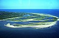
 Worlds End State Park, Loyalsock Creek canyon
 -

-
 Ohiopyle State Park,
Jonathan Run Falls


History
Pennsylvania's first state park was Valley Forge State Park, purchased by the Commonwealth on May 30, 1893, to preserve Valley Forge. It was transferred to the National Park Service (NPS) on the Bicentennial of the United States, July 4, 1976.[9] Many state parks still preserve history: as of 2012, forty-two Pennsylvania state park sites are on the National Register of Historic Places, including two National Historic Landmarks (Delaware Canal and Point), twenty-eight Civilian Conservation Corps sites in nineteen parks, and twelve other parks' historic sites and districts.[10] Eight of the former state parks were also chiefly historic.[4]
In addition to preserving historic sites, Pennsylvania also sought to preserve natural beauty and offer opportunities for recreation in its state parks. In 1902 Mont Alto State Forest Park was the second park established, a year after the state "Bureau of Forestry" was set up to purchase, preserve, and restore Pennsylvania's forests, which had been ravaged by lumbering, charcoal production, and wild fires. Parks were added sporadically until the 1930s, some mere camping and picnic areas in state forests, while others preserved unique sites.[11] The 1930s saw a great expansion of parks and their facilities under Governor Gifford Pinchot, who cooperated with President Franklin Roosevelt, despite their being of different political parties. The Civilian Conservation Corps (CCC) established 113 CCC camps in Pennsylvania (second only to California). Using CCC and Works Progress Administration (WPA) labor, the NPS built five Recreation Demonstration Areas, which became Pennsylvania state parks in 1945 and 1946: Blue Knob, French Creek, Hickory Run, Laurel Hill, and Raccoon Creek. The CCC also "fought forest fires, planted trees, built roads, buildings, picnic areas, swimming areas, campgrounds and created many state parks".[12]
In 1956, there were forty-four state parks in Pennsylvania, mostly in rural areas. Forty-five parks had been added by 1979, mostly near urban areas, and the system had increased by 130,000 acres (53,000 ha). This was thanks largely to the efforts of Maurice K. Goddard, who served as director of the precursors to the DCNR for twenty-four years under six administrations. The number of visitors to parks more than tripled in this time and two voter approved bond issues (Projects 70 and 500) raised millions of dollars for park expansions and improvements.[5] All this expansion was not without costs and by 1988 there was an estimated $90 million in deferred maintenance. In 1993, as the park system celebrated its one-hundredth anniversary, new tax and bond revenues were earmarked for the parks.[3] Since 2000, parks are being improved through the state's Growing Greener and Growing Greener II and bond programs.[13]
-
-
 Codorus State Park,
man-made Lake Marburg -
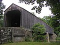
 Ravensburg State Park, CCC picnic shelter
 -
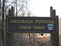 Archbald Pothole State Park, typical entrance sign


Current parks
| Park name | County or counties | Area in acres (ha) | Date founded |
Stream(s) and / or lake(s) | Remarks | Image |
|---|---|---|---|---|---|---|
| Allegheny Islands State Park | Allegheny County | 43 acres (17 ha) |
1980 | Allegheny River | Three alluvial islands near Pittsburgh with no facilities, and accessible only by boat |  |
| Archbald Pothole State Park | Lackawanna County | 150 acres (61 ha) | 1964 | None | One of world's largest potholes, 38 ft (12 m) deep, largest diameter 42 feet (13 m) by 24 feet (7 m) |  |
| Bald Eagle State Park | Centre County | 5,900 acres (2,388 ha) | 1971 | Bald Eagle Creek, Foster Joseph Sayers Reservoir | 1,730 acre (700 ha) U.S. Army Corps of Engineers reservoir named for Medal of Honor recipient |  |
| Beltzville State Park | Carbon County | 2,973 acres (1,203 ha) | 1972 | Pohopoco Creek, Beltzville Lake | U.S. Army Corps of Engineers lake is 949 acres (384 ha) with 19.8 miles (31.9 km) of shoreline. |  |
| Bendigo State Park | Elk County | 100 acres (40 ha) | 1959 | East Branch Clarion River | Only 20 acres (8.1 ha) developed, name a corruption of Abednego |  |
| Benjamin Rush State Park | Philadelphia County | 275 acres (111 ha) | 1975 | None | Site of one of the world's largest community gardens, otherwise undeveloped |  |
| Big Elk Creek State Park | Chester County | 1,712 acres (693 ha) |
2022 | Elk River (Maryland) | Big Elk Creek was an important transportation and natural resource corridor for indigenous people for thousands of years and an important area for freedom seekers on the Underground Railroad to the North. | |
| Big Pocono State Park | Monroe County | 1,306 acres (529 ha) | 1954 | None | On Camelback Mountain, site of Camelback Ski Area and Waterpark |  |
| Big Spring State Forest Picnic Area | Perry County | 45 acres (18 ha) |
1936 | Big Spring Run [14] (which forms Shermans Creek) | Park has trail to partially completed railroad tunnel in Conococheague Mountain. |  |
| Black Moshannon State Park | Centre County | 3,394 acres (1,374 ha) | 1937 | Black Moshannon Creek, Black Moshannon Lake | Park has bog with three carnivorous plant species and 17 orchid varieties. |  |
| Blue Knob State Park | Bedford County | 5,874 acres (2,377 ha) | 1945 | None | This former Recreation Demonstration Area on the state's second highest mountain has Blue Knob All Seasons Resort (skiing). |  |
| Boyd Big Tree Preserve Conservation Area | Dauphin County | 914 acres (370 ha) | 1999 | Unnamed tributary of Fishing Creek | On Blue Mountain, one of three Conservation Areas, named for donor Alex Boyd |  |
| Buchanan's Birthplace State Park | Franklin County | 18.5 acres (7 ha) |
1911 | Buck Run | Stone pyramid marks the birthplace of James Buchanan, 15th President of the United States. |  |
| Bucktail State Park Natural Area | Cameron and Clinton Counties | 21,039 acres (8,514 ha) | 1933 | Sinnemahoning Creek, West Branch Susquehanna River | Park, named for the Bucktail Regiment, is a 75-mile (121 km) undeveloped scenic drive on PA 120. |  |
| Caledonia State Park | Adams and Franklin Counties | 1,125 acres (455 ha) | 1903 | Rocky Mountain Creek, Carbaugh Run, East Branch Conococheague Creek | Park, named for Thaddeus Stevens' iron furnace, is home to summer stock Totem Pole Playhouse. |  |
| Canoe Creek State Park | Blair County | 658 acres (266 ha) | 1979 | Canoe Creek (tributary of Raystown Branch Juniata River), Canoe Creek Lake | Home of largest nursery colony of little brown bats in the state. |  |
| Chapman State Park | Warren County | 805 acres (326 ha) | 1951 | Farnsworth Run, West Branch Tionesta Creek, Chapman Lake | Trailhead for trail system in surrounding Allegheny National Forest |  |
| Cherry Springs State Park | Potter County | 48 acres (19 ha) |
1922 | None | Park known for some of the clearest, darkest night skies in the state and eastern US. |  |
| Clear Creek State Park | Jefferson County | 1,676 acres (678 ha) | 1922 | Clear Creek, Clarion River | Start of popular canoe trip on 10 miles (6 km) of Clarion River to Cook Forest State Park |  |
| Codorus State Park | York County | 3,329 acres (1,347 ha) | 1966 | Codorus Creek, Lake Marburg | Man-made lake is 1,275 acres (516 ha), named for former village of Marburg now flooded by it. |  |
| Colonel Denning State Park | Cumberland County | 273 acres (110 ha) | 1936 | Doubling Gap Creek, Doubling Gap Lake | Park named for William Denning, an American Revolutionary War veteran who was never a colonel. |  |
| Colton Point State Park | Tioga County | 368 acres (149 ha) | 1936 | Pine Creek | On west rim of the Pennsylvania Grand Canyon, 800 feet (244 m) deep here |  |
| Cook Forest State Park | Clarion, Forest, and Jefferson Counties | 8,500 acres (3,440 ha) | 1927 | Toms Run, Clarion River | National Natural Landmark, one of America's top-50 state parks (National Geographic Traveler) |  |
| Cowans Gap State Park | Franklin and Fulton Counties | 1,085 acres (439 ha) | 1937 | Little Aughwick Creek, Cowans Gap Lake | Site of French and Indian War road, pioneer homestead, lumbering, and CCC camp |  |
| Delaware Canal State Park | Bucks and Northampton Counties | 830 acres (336 ha) | 1931 | Delaware River | Park runs 60 miles (97 km) along Delaware Canal, the only 19th century U.S. towpath canal left continuously intact. |  |
| Denton Hill State Park | Potter County | 700 acres (283 ha) | 1951 | None | Site of Ski Denton resort, also open for summer mountain biking |  |
| Elk State Park | Elk and McKean Counties | 3,192 acres (1,292 ha) | 1963 | East Branch Clarion River, East Branch Lake | U.S. Army Corps of Engineers lake is 1,160 acres (470 ha). |  |
| Erie Bluffs State Park | Erie County | 540 acres (219 ha) | 2004 | Lake Erie | Park has 1.0 mile (0.6 km) of lake coastline and bluffs 90 feet (27 m) tall, and is being developed. |  |
| Evansburg State Park | Montgomery County | 3,349 acres (1,355 ha) | 1979 | Skippack Creek | Park has 18 hole Skippack Golf Course and many outdoor recreational opportunities. |  |
| Fort Washington State Park | Montgomery County | 493 acres (200 ha) | 1953 | Wissahickon Creek | George Washington camped here in the American Revolutionary War's Philadelphia campaign. |  |
| Fowlers Hollow State Park | Perry County | 104 acres (42 ha) | 1936 | Fowlers Hollow Run | Trailhead for the trail system of the surrounding Tuscarora State Forest |  |
| Frances Slocum State Park | Luzerne County | 1,035 acres (419 ha) | 1968 | Abrahams Creek, Frances Slocum Lake | Park named for a girl kidnapped by the Lenape who lived the rest of her life with the Miami in Indiana. |  |
| French Creek State Park | Berks and Chester Counties | 7,339 acres (2,970 ha) | 1946 | French Creek | Former Recreation Demonstration Area, adjacent to Hopewell Furnace National Historic Siteg |  |
| Gifford Pinchot State Park | York County | 2,338 acres (946 ha) | 1961 | Beaver Creek (tributary of Conewago Creek), Pinchot Lake | Gifford Pinchot was a Pennsylvania governor, conservationist, and first US Forest Service Chief. |  |
| Gouldsboro State Park | Monroe and Wayne Counties | 2,880 acres (1,165 ha) | 1958 | Gouldsboro Lake | Park named for village named for Jay Gould, next to Tobyhanna Army Depot. |  |
| Greenwood Furnace State Park | Huntingdon County | 423 acres (171 ha) | 1924 | Standing Stone Creek, Greenwood Lake | Includes ghost town of Greenwood, former ironworks and charcoal hearthsfg |  |
| Hickory Run State Park | Carbon County | 15,550 acres (6,293 ha) | 1945 | Hickory Run, Lehigh River, Sand Spring Lake | Former Recreation Demonstration Area with a large boulder field that is a National Natural Landmark.df |  |
| Hillman State Park | Washington County | 3,600 acres (1,456 ha) | 1960s | Raccoon Creek | Managed for hunting by the Pennsylvania Game Commission and largely undeveloped |  |
| Hills Creek State Park | Tioga County | 407 acres (165 ha) | 1953 | Hills Creek, Hills Creek Lake | Land previously used as a pigment mine for the paint industry |  |
| Hyner Run State Park | Clinton County | 180 acres (73 ha) | 1958 | Hyner Run | On the site of Civilian Conservation Corps Camp S-75-PA |  |
| Hyner View State Park | Clinton County | 6 acres (2 ha) |
1965 | None | Scenic view of the West Branch Susquehanna River and launching point for hang glidingf |  |
| Jacobsburg Environmental Education Center | Northampton County | 1,168 acres (473 ha) | 1959 | Bushkill Creek | Park surrounds Jacobsburg National Historic District, where rifles were manufactured during the American Revolution.g |  |
| Jennings Environmental Education Center | Butler County | 300 acres (121 ha) | 1979 | Big Run | Park contains the only publicly protected relict prairie ecosystem in Pennsylvania, 20 acres (8.1 ha).f |  |
| Joseph E. Ibberson Conservation Area | Dauphin County | 350 acres (142 ha) | 2000 | None | On Peters Mountain, one of three Conservation Areas, named for donor Joseph E. Ibberson |  |
| Kettle Creek State Park | Clinton County | 1,793 acres (726 ha) | 1954 | Kettle Creek, Kettle Creek Reservoir | U.S. Army Corps of Engineers reservoir is 160 acres (65 ha), park has many recreational facilities built by CCC. |  |
| Keystone State Park | Westmoreland County | 1,200 acres (486 ha) | 1945 | Keystone Run, Keystone Lake | Park is named for the Keystone Coal and Coke Company that once owned the land and created the lake. |  |
| Kings Gap Environmental Education and Training Center | Cumberland County | 1,454 acres (588 ha) | 1973 | some vernal pools, Kings Gap Hollow Run, Irish Gap Run | Training center for park rangers of the Pennsylvania Department of Conservation and Natural Resources |  |
| Kinzua Bridge State Park | McKean County | 329 acres (133 ha) | 1970 | Kinzua Creek | Had 1882 Historic Civil Engineering Landmark railway bridge, once the world's highest and longest, destroyed by a tornado in 2003.fg |  |
| Kooser State Park | Somerset County | 250 acres (101 ha) | 1922 | Kooser Run, Kooser Lake | Site of battles between Native American tribes, part of Whiskey Rebellion g |  |
| Lackawanna State Park | Lackawanna County | 1,411 acres (571 ha) | 1972 | South Branch Tunkhannock Creek, Lake Lackawanna | On site of a Turn of the Century era community fair |  |
| Laurel Hill State Park | Somerset County | 3,935 acres (1,592 ha) | 1945 | Laurel Hill Creek, Laurel Hill Lake | Former Recreation Demonstration Area with the largest CCC architecture collection of any Pennsylvania state parkg |  |
| Laurel Mountain State Park | Somerset and Westmoreland Counties | 493 acres (200 ha) | 1964 | None | Opened in 1939 by Richard K. Mellon and Rolling Rock brewery as one of the state's first ski areas, donated to the state in 1964 |  |
| Laurel Ridge State Park | Cambria, Fayette, Somerset and Westmoreland Counties | 13,625 acres (5,514 ha) | 1967 | Conemaugh River, Youghiogheny River and tributaries | The park surrounds the 70 mile (113 km) long Laurel Highlands Hiking Trail. |  |
| Laurel Summit State Park
Zdroj:https://en.wikipedia.org?pojem=Pennsylvania_Bureau_of_State_Parks >Text je dostupný pod licencí Creative Commons Uveďte autora – Zachovejte licenci, případně za dalších podmínek. Podrobnosti naleznete na stránce Podmínky užití. Zdroj: Wikipedia.org - čítajte viac o Pennsylvania Bureau of State Parks
Řetízek (ozdoba)
Šátek Beadweaving Bižuterie Bolo Dřevěný motýlek Deštník Digitálky Faléra Fiží Text je dostupný za podmienok Creative
Commons Attribution/Share-Alike License 3.0 Unported; prípadne za ďalších
podmienok. |

