A | B | C | D | E | F | G | H | CH | I | J | K | L | M | N | O | P | Q | R | S | T | U | V | W | X | Y | Z | 0 | 1 | 2 | 3 | 4 | 5 | 6 | 7 | 8 | 9
Hamirbati | |
|---|---|
Village | |
 Hamirbati Location in West Bengal, India  Hamirbati Hamirbati (India) | |
| Coordinates: 22°50′04″N 87°51′03″E / 22.8344°N 87.8507°E | |
| Country | |
| State | West Bengal |
| District | Hooghly |
| Population (2011) | |
| • Total | 1,754 |
| Languages | |
| • Official | Bengali, English |
| Time zone | UTC+5:30 (IST) |
| PIN | 712413 |
| Telephone/STD code | 03211 |
| Lok Sabha constituency | Arambagh |
| Vidhan Sabha constituency | Arambag |
| Website | hooghly |
Hamirbati is a village in the Arambagh CD block in the Arambagh subdivision of Hooghly district in the Indian state of West Bengal.
Geography

5miles
River
River
River
River
Bayara
M: municipal city/ town, R: rural/ urban centre, H: historical/ religious centre
Owing to space constraints in the small map, the actual locations in a larger map may vary slightly
Location
Hamirbati is located at 22°50′04″N 87°51′03″E / 22.8344°N 87.8507°E
Area overview
The Arambagh subdivision, presented in the map alongside, is divided into two physiographic parts – the Dwarakeswar River being the dividing line. The western part is upland and rocky – it is the extension of the terrain of neighbouring Bankura district. The eastern part is flat alluvial plain area. The railways, the roads and flood-control measures have had an impact on the area.[1] The area is overwhelmingly rural with 94.77% of the population living in rural areas and 5.23% in urban areas.[2]
Note: The map alongside presents some of the notable locations in the subdivision. All places marked in the map are linked in the larger full screen map.
Demographics
As per the 2011 Census of India, Hamirbati had a total population of 1,754 of which 895 (51%) were males and 859 (49%) were females. Population in the age range 0–6 years was 225. The total number of literate persons in Hamirbati was 1,202 (78.61% of the population over 6 years).[3]
Hamirbati picture gallery
-
 Damodar temple, at chala, built in 1704.
 -
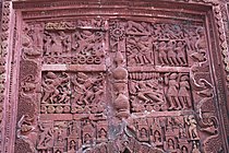 Terracotta relief at Damodar temple.
 -
 Terracotta relief at Damodar temple.
.jpg)
.jpg)
.jpg)
References
- ^ "District Census Handbook: Hugli, Series-20, Part XIIA" (PDF). Physiography, Page 17-19. Directorate of Census Operations, West Bengal, 2011. Retrieved 25 September 2020.
- ^ "District Statistical Handbook 2014 Hooghly". Table 2.2, 2.4(a). Department of Planning and Statistics, Government of West Bengal. Retrieved 25 September 2020.
- ^ "2011 Census – Primary Census Abstract Data Tables". West Bengal – District-wise. Registrar General and Census Commissioner, India. Retrieved 22 September 2020.
External links
This article about a location in the Hooghly district of West Bengal is a stub. You can help Wikipedia by expanding it. |
>Text je dostupný pod licencí Creative Commons Uveďte autora – Zachovejte licenci, případně za dalších podmínek. Podrobnosti naleznete na stránce Podmínky užití.
Text je dostupný za podmienok Creative
Commons Attribution/Share-Alike License 3.0 Unported; prípadne za ďalších
podmienok.
Podrobnejšie informácie nájdete na stránke Podmienky
použitia.

